Overview
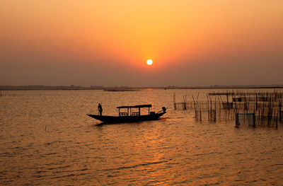
The Chilika Lake, located on the east coast of the state of Orissa, India is the largest lagoon and salt water lake in Asia. It is separated from the Bay of Bengal by a sand bar that varies from 100m to 1.5 km. A long outer channel stretching 32 km connects the main lagoon with the Bay of Bengal. The lagoon spread over an area larger than a 1000 sq. km in the early 20th century, however, during the course of the 20th century the lake shrank to only 760 sq km due to direct reclamation of shoreline areas for agriculture, aquaculture, and human settlements. The Chilika lagoon remains a vital resource for more than 200,000 people in 141 villages who live in around the lagoon. The communities in the Mahanadi river basin subsist on agricultural practices but the villagers around the lagoon area are dependent on aquaculture and the lake’s fisheries for their livelihoods. Construction of hydraulic systems altered the Mahanadi’s flow into Chilika, and the intensification of agriculture in the 20th century has led to numerous problems. Major conflicts began with the alteration of fishing policy and was further exacerbated by big investment that poured into the area from outside the state. This restoration project sought to protect the lake’s ecosystem and biodiversity, mitigate the conflicts, and restore the lake by developing a proposal for integrated resource management around the lake.
Quick Facts
Project Location:
Chilika lake , Odisha, Chilika, Odisha, India, 19.7400546, 85.36067290000005
Geographic Region:
Asia
Country or Territory:
India
Biome:
Coastal/Marine
Ecosystem:
Estuaries, Marshes & Mangroves
Project Lead:
Chilika Development Authority
Organization Type:
Governmental Body
Location
Project Stage:
Completed
Start Date:
1992-01-01
End Date:
2006-01-01
Primary Causes of Degradation
Agriculture & Livestock, Fisheries & Aquaculture, Urbanization, Transportation & Industry, OtherDegradation Description
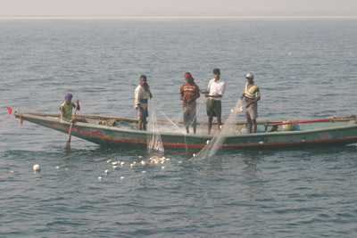
The Chilika lake was spread over 908 sq. km., in the summer and 1165 sq. km., during monsoon in the early part of 20th Century. But by the mid-1980’s the average water spread was estimated at only 790 sq. km., and by late 1990’s it had reduced to 760 sq. km., according to Landsat TM data. This can be attributed to increased reclamation of shoreline areas for agriculture, aquaculture and human settlements. The construction of major hydraulic systems upstream has altered the flow of water into Chilika. The long shore sediment transport along the coast of Bay of Bengal is estimated to be 0.1 million metric tons annually and tends to shift the mouth opening to the sea every year, adversely affecting the tidal exchange. The upstream erosion and sedimentation process in the lagoon directly contributes to the loss of depth of lake bed and also to the choking of the mouth; this in turn led to the decline in salinity which resulted in rapid growth of invasive weed species and macrophytes disturbing the delicate ecosystem of the lake.”¨ In the lagoon area itself, conflict started by changing a basic policy entitling non-fishermen community to use water spread area for traditional culture fishery. Major conflict started when big investment began pouring in from other parts of the state and even from outside the state. The leasing system broke down completely in 1991 when the Orissa government outlined a leasing policy that would in essence have resulted in the auction of leases to the highest bidder. The cooperatives challenged the order in court, and the Orissa High Court directed the Government to make changes that would safeguard traditional fishermen’s interests.
Reference Ecosystem Description
Geological studies suggest that the coastline extended along the western shores of Chilika in the Pleistocene era, and that the entire northeastern region above Chilika was under the ocean. Since then, the coastline has moved considerably eastward. For instance, the Konark temple was built on the seashore a few hundred years ago and is now over 3 km from the coast. Most lagoons seen today were formed as a result of a worldwide rise in sea levels over the last 6,000-8,000 years. There was a pause in the rise in sea levels about 7,000 years ago, when a sandy beach formed near the coast and as the sea rose further this sandy beach gradually grew. It progressed seaward and to the northeast, to form what is now the spit of Chilika. A recent fossil from the southwestern edge of the spit has been dated to about 3,500-4,000 years ago, which is some indication of how long ago the lagoon was formed. The growth of the spit at Chilika is thought to be due to the abrupt change in the direction of the coast north of the lake, where strong winds transfer sand to the shore, the longshore drift, and the presence of strong river and tidal currents in these different areas. The spit of Chilika is constantly changing. The sand bar has been widening, and the position of the mouth contantly shifting, moving generally towards the northeast. The mouth was described as being about 1.5 km wide in 1780, and had decreased to half that within forty years. The mouth frequently gets choked up and has to be cut open artificially, often by the local fisherfolk, whose livelihood depends critically on maintaining an access for the sea to enter Chilika. Meanwhile, the former seabed underlying Chilika is gradually silting up because of the rivers running into it, converting the lagoon to its present shallow state. The lagoon is a unique assemblage of marine, brackish and fresh water eco-system with estuarine characteristics. It is one of the hotspots of biodiversity in the region and shelters a number of endangered species listed in the IUCN red list of threatened species, as well as being designated a Ramsar site. It is significant avian habitat and the wintering ground for more than one million migratory birds. The highly productive lagoon eco-system with its rich fishery resources sustains the livelihood of more than 150,000 fisher folk who live in and around Chilika. The area of the Lagoon varies between 1165 to 906 sq. km during the monsoon and summer respectively. The total number of fish species is reported to be 225. Along with a variety of phytoplankton, algae and aquatic plants, the Chilika region also supports over 720 species of non-aquatic plants (CDA). A survey of the fauna of Chilika carried out by the Zoological Survey of India in 1985-87 recorded over 800 species in and around the lagoon. This includes a number of rare, threatened and endangered species, including the Barakudia limbless skink. Chilika is an extremely productive environment due largely to the high nutrient input from surrounding rivers, as well as efficient nutrient re-cycling. This high productivity supports fisheries for both fish and shell fish. Chilika is an ephemeral environments (on geological time scales) and is evolving rapidly into other types of semi-aquatic, habitats (marshes, swamps). Simultaneous with this succession is a gradual shift from high salinity conditions to freshwater.
Project Goals
The restoration of the Chilika Lake started with the following basic objectives: 1) To restore the ecological balance of the lake; 2) Provide continued livelihood to the villages surrounding the lake/lagoon.
Monitoring
The project does not have a monitoring plan.
Stakeholders
The basic approach adopted for restoration was to facilitate a community based co-management system for an integrated terrestrial and aquatic resource management program, with a major emphasis on capacity building at the community level. This was done through a series of training and exposure visits, designed to pave the way for preparation of a watershed plan that blended indigenous knowledge at the community level for optimum utilization of the natural resources and an increase in the area’s productivity. The increase in the productivity level is also helping in the poverty alleviation in the catchment area. The watershed community also shares part of the cost of the treatment. This is creating an enabling situation for the local community to make decisions for natural resource management within the catchment basin. There are 8 micro watersheds covering an area of 1000 sq kms and include more than 52 villages.”¨The network of the NGOs and CBOs, wide stakeholders consultation, watershed associations are some of the positive elements in the participatory management approach adopted by CDA. The self-initiated sustainable practices are an indication of the confidence that has been regained by the stakeholders on the lagoon ecosystem.
Description of Project Activities:
The spatial and temporal salinity gradients that exist in Chilika give it the unique characteristics of an estuarine eco-system, which exercises a continuous and selective influence on its biota. The transformation of the lagoon towards a fresh water ecosystem was considered as a potential threat to its unique ecosystem. To address this problem, CDA commissioned the services of the premier institutes of the country like National Institute of Oceanography, (NIO) to study the wave climate of the inlet, long shore sediment transport along the shore and the bathymetry of the lead channel. The Central Water and Power Research Station (CWPRS), carried out the hydrological and two dimensional mathematical model studies. The studies concluded that the tidal influx into the lagoon was considerably reduced because of the shoal formation along the lead channel and continuous shifting of the mouth that resulted in significant hydraulic head loss.
Opening of a new mouth"¨
Following the recommendations of the CWPRS, an artificial mouth was opened on 23rd September 2000, which reduced the length of the outflow channel by 18 km. This is considered historic for restoration ecology. Desiltation of the lead channel was completed before opening the new mouth. The environment impact assessment and the monitoring of the lagoon ecosystem were carried out by National Institute of Oceanography, before and after the intervention. Monitoring results indicated that there is a marked improvement in the lagoon ecosystem.
The other components of the restoration program were community-based treatment of the catchment on a micro watershed basis, restoration of Nalabana bird Sanctuary and improvement of bird habitats with the active participation of the community. Awareness campaigns and environmental education, development of a visitor center, improvements of communication network, close monitoring of the lagoon and a research center on wetland management.
The opening of the artificial mouth and the desiltation of the lead channel not only rejuvenated the lagoon ecosystem but also immensely benefited the fisher folk whose average annual income increased by more than 50,000 rupees per annum per family. Overall, the restoration has resulted in the desired improvement of the salinity regime of the lagoon. Marked improvement in the fishery resources of the lagoon as the gradual reduction in the salinity from the lagoon mouth to the lagoon proper after the opening of the mouth is providing the desirable sense of direction for the eurohaline forms to enter into the lagoon from the sea. This is facilitating the auto-recruitment of the fish, prawn, and crab juveniles into the lagoon resulting in a remarkable improvement of the fishery resources. The fish landing, which had declined on an average to a mere 1600 metric tons (MT) during the year 2000-2001 improved to 4889.21 MT and in the seven months after the opening of new mouth i.e. from October 2000 to March 2001 alone was 3718.44 MT. During the year 2001-2002, it recorded to be 11988.88 MT. It registered an all time high record of 14,053.22 MT during 2003-04. The fish landing is recorded to be 13,260.37 MT during 2004-05. It is registered to be 12224.91 MT during 2005-2006. The crab landing which dwindled to a low of 10 MT in 1999-2000 improved to 161.89 in 2004-2005. During the year 2005-2006, total prawn landing was registered to be 4296.02 MT and Crab landing was recorded to be 154.08 MT. This has facilitated the self-initiated good practices by the community like regulation of the mesh size, ban on juvenile poaching etc. Due to improvement of the salinity gradient there is a phenomenal decrease of the fresh water invasive species by 172 sq kilometers and improvement of the sea grass bed. The improvement of the tidal flux has resulted in the better flushing of the sediment to the sea through the outlet channel. There is a significant improvement in the water level variation during the tidal cycle, which has turned the lagoon in to pulsing mode, thus making it more productive by nourishment with additional nutrient and flushing out of the detritus and waste products efficiently.
Ecological Outcomes Achieved
Eliminate existing threats to the ecosystem:
There have been remarkable changes in the ecosystem of the Chilika Lake since the restoration process was initiated. The major achievements were:
1. Salinity Change: Salinity level in the northern sector changed from 0.5 - 2.5 ppt recorded in the last decade to 0.1-36.00 ppt.
2. Fishery productivity : The fish land, which had declined to 1600 MT before intervention changed to 11,877 mt in 2001-2002 and crab landing increased from 3 MT in 1994-95 to"¨150 MTs in 2002-03. There is also a marked change in ranking order.
3. Auto recruitment of fish, prawn and crab: The fish and crab landing data further indicate the significant level of increase in auto recruitment from the sea into the lake after intervention. The shrimp species Paenaus indicus alone showed a record yield of 438 MT, which is higher than any other figure in the last decade.
4. Decline in weed infestation : The trend of invasive fresh water species reaching an area of 523.01 sq. km., in 2000 (October) leaving an weed free area of 333.82 sq. km., was greatly changed following a reduction of 172 sq. km., of weed spread area."¨ "¨
5. Depth of Channel: The opening of mouth and consequent changes in tidal flux led to significant flushing of sediment from the channel thereby increasing the depth to 30-45 cm level.
Apart from ecological improvements the other social impacts from this restoration were:
1) Changes in local community income: lake restoration resulted in enhanced fish and crab yield thereby increasing the per capita average annual income by 50,000 rupees.
2) Improved stakeholder awareness: the stakeholders have self adopted good practices like regulation of mesh size, discouraging juvenile catches."¨
3) A better linkage has been established between CDA and fisher community following implementation of action plan."¨
4) Overall improved Chemical, Physical and Biological parameters
Socio-Economic & Community Outcomes Achieved
Economic vitality and local livelihoods:
The hydrological interventions taken for the restoration of the lagoon have resulted in considerable improvement of its fishery resources, water quality, positive impact on the biodiversity and an overall improvement of the ecosystem of the lagoon. This has significantly contributed towards the increase in the per capita income of the community who depend on the lagoon for their livelihood. The increase in the productivity level both in the wetland as well as in the watershed due to the good environmental practices has facilitated the economic improvement of the community. The community participation, linkage with the various national and international institutions, intensive monitoring and assessment system are some of the uniqueness of the management practices adopted by CDA for restoration of this unique wetland. The restoration approach of CDA is considered as most appropriate and unique in the history of restoration ecology. Ramsar Advisory Mission, based on their assessment of the the management interventions, have recommended for removal of Chilika lagoon from the Montreux record. Chilika Development Authority is also conferred with prestigious Ramsar wetland Award-2002, in view of its outstanding achievements in the field of restoration and wise use of the wetlands, as well as the impressive way in which local communities have been involved in these activities.
Long-Term Management
There are a number of studies being actively carried out, or that have been carried out at Chilika, all of them sponsored by the Chilika Development Authority. This is a sampling of some:
1. Mathematical model studies for Chilika Lake 1992 by CWPRS, Pune.
2. Studies on waves and long shore sediment transport along the coast line of Chilika Lake 1992 by NIO, Goa.
3. Report of Chilika Database for the year 1991-92 with ORSAC.
4. Studies on directional wave along the coast line of Chilika Lake 1994 by NIO Goa.
5. Investigations on Eutrophication problems in Chilika Lake – 1994 with RRL, Bhubaneswar.
6. Characteristics of the existing Chilika Lake inlet channel-1994 with lNIO Goa.
7. Report on Chilika Database – 1995 with ORSAC.
8. Brief Activity report – 1995 by CDA.
9. Mathematical model studies to assess the effect of proposed channel on flow circulation and salinity in Chilika Lake, Orissa 1995 – CWPRS, Pune.
10. Studies on Directional Wave along the coastline of Chilika Lake – 1995 with NIO, Goa.
11. Studies on volume of dredging at Chilika Lake – 1996 with NIO, Goa.
12. A socio-economic study of the peripheral villages of Chilika Lake (A preliminary Report – 1996) Anthropology Department, Utkal University, Bhubaneswar.
13. 2-D Mathematical model studies to assess the effect of proposed channel on salinity improvement in Chilika Lake;, Orissa – 1997 with CWPRS, Pune.
14. Mathematical Model studies to assess the effect of proposed channel on flow circulation and salinity in the Chilika Lake, Orissa – 1998 with CWPRS, Pune.
15. A report on the present status of weeds in Chilika lagoon – 1998 with Botany Department, Utkal University, Bhubaneswar.
16. Bathymetric survey at Magarmukh in Chilika Lake – 1998 lwith ICH. Goa.
17. Environmental Monitoring of Chilika Lagoon – 1994 with ORSAC.
18. Environmental Monitoring of Chilika Lagoon 1995 – 1996 with ORSAC.
19. Report on Chilika Database (1994-95 & 1995-96) – 1998 with ORSAC.
20. Mathematical Model studies to assess the effect of the proposed straight cut near Satapada on flow conditions and salinity distribution in the Chilika Lake (Orissa) – 1998.
21. Studies on waves and long shore sediment transport alay coast line of Chilika Lake – 1998.
22. Activities of Chilika Development Authority 1995-96.
23. Annual Management Action Plan 1998.
24. Hydrobiological monitoring Action Plan for Chilika Lake – 1998.
25. Sustainable Development of Chilika Lake, Orissa – 1998.
26. Monitoring of Chilika Lake by NIO Goa ,1999
Sources and Amounts of Funding
570 million rupees The entire issue of better lagoon management and the restoration program was initiated after receiving 270 million INR special problem area grant as per the recommendation of the 10th Finance Commission and further assistance of 300 million INR approved by the 11th Finance Commission.