- News
- City News
- chennai News
- Another tsunami can flood up to 2km into Chennai
Trending
This story is from December 27, 2022
Another tsunami can flood up to 2km into Chennai
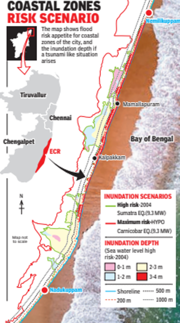
If a tsunami strikes again, seawater may enter nearly half a kilometre into the land on East Coast Road and a 30km stretch from Nemili to Kadalur Periyakuppam including Mamallapuram and Kalpakkam may go under 3m to 4m water.

People pay tribute to the victims of the 2004 Tsunami on its 18th anniversary, at Nochikuppam beach, in Chennai on Monday
If a tsunami strikes again, seawater may enter nearly half a kilometre into the land on East Coast Road and a 30km stretch from Nemili to Kadalur Periyakuppam including Mamallapuram and Kalpakkam may go under 3m to 4m water.
Royapuram, Beach Railway Station, Triplicane, Lighthouse and Santhome may go under 3m deep water, while areas around Napier’s Bridge (over Cooum) and Elphinstone Bridge (over Adyar) may get inundated up to 2m.
These are findings from a simulated study by Chennai-based National Centre for Coastal Research (NCCR) and Hyderabad-based Indian National Centre for Ocean Information Services (INCOIS), taking the 2004 tsunami, triggered by a 9. 3 magnitude earthquake off north Sumatra coast, as the worst-case scenario.

“In 2004, districts like Cuddalore and Nagapattinam were inundated up to 3km inland. In Chennai, it was around 1km into the land while at Visakhapatnam, water entered only 500m. It depends on the topography.
If the terrain is flat, water travels more into land than compared to an incline off the shore,” said INCOIS scientist
According to the study, northern suburbs like Pazhaverkadu, which has Pulicat lake, may see inundation of up to 1m beyond 1km into the land and 1m to 3m water level near the coast.
Similarly, up to 200m of land from Besant Nagar up to Panaiyur along East Coast Road may go under 2-3m water. From Uthandi to Muttukadu water may go up to 3m up to 500m into land.
Some places in and around Mamallapuram and Salavankuppam may go under 2m water depth up to 1km into the land. Beyond that, much of East Coast Road is likely to face inundation of 2m to 3m along the coast.
NCCR director M V Ramana Murthy said they run a numerical model with probable earthquake scenarios to compute the wave height at the source (epicentre) and calculate its impact as it reaches the coast, for which data on the topography, physical features of the coast and sea bathymetry are taken into account.
“In the delta regions of the state, wave height might be amplified and cause more inundation as the seabed bathymetry in these areas have a mild slope,” he said.
So, will the 2004-tsunami happen again on the east coast? INCOIS scientists say there are chances of an earthquake of nearly 8m in Andaman and Nicobar as quakes of 8m have a return period of 100 years +20 years. The last quake of 7. 9m in Andaman and Nicobar was in 1881 that triggered a tsunami.
Royapuram, Beach Railway Station, Triplicane, Lighthouse and Santhome may go under 3m deep water, while areas around Napier’s Bridge (over Cooum) and Elphinstone Bridge (over Adyar) may get inundated up to 2m.
These are findings from a simulated study by Chennai-based National Centre for Coastal Research (NCCR) and Hyderabad-based Indian National Centre for Ocean Information Services (INCOIS), taking the 2004 tsunami, triggered by a 9. 3 magnitude earthquake off north Sumatra coast, as the worst-case scenario.
The two labs have developed tsunami hazard maps for the 7,500km Indian coast based on various earthquake scenarios for issuing tsunami early warnings.
“In 2004, districts like Cuddalore and Nagapattinam were inundated up to 3km inland. In Chennai, it was around 1km into the land while at Visakhapatnam, water entered only 500m. It depends on the topography.
If the terrain is flat, water travels more into land than compared to an incline off the shore,” said INCOIS scientist
Ajay Kumar B.
According to the study, northern suburbs like Pazhaverkadu, which has Pulicat lake, may see inundation of up to 1m beyond 1km into the land and 1m to 3m water level near the coast.
Similarly, up to 200m of land from Besant Nagar up to Panaiyur along East Coast Road may go under 2-3m water. From Uthandi to Muttukadu water may go up to 3m up to 500m into land.
Some places in and around Mamallapuram and Salavankuppam may go under 2m water depth up to 1km into the land. Beyond that, much of East Coast Road is likely to face inundation of 2m to 3m along the coast.
NCCR director M V Ramana Murthy said they run a numerical model with probable earthquake scenarios to compute the wave height at the source (epicentre) and calculate its impact as it reaches the coast, for which data on the topography, physical features of the coast and sea bathymetry are taken into account.
“In the delta regions of the state, wave height might be amplified and cause more inundation as the seabed bathymetry in these areas have a mild slope,” he said.
So, will the 2004-tsunami happen again on the east coast? INCOIS scientists say there are chances of an earthquake of nearly 8m in Andaman and Nicobar as quakes of 8m have a return period of 100 years +20 years. The last quake of 7. 9m in Andaman and Nicobar was in 1881 that triggered a tsunami.
End of Article
FOLLOW US ON SOCIAL MEDIA


Hot Picks
TOP TRENDING
Trending Stories
In City
Entire Website
- LS election phase 3: 11% polling till 9am; highest voter turnout in Bengal, lowest in Maharashtra
- LS polls: Gujarat records 9.87% voter turnout till 9 am
- LS polls: Maharashtra records lowest voter turnout till 9 am
- HPBOSE 10th Result 2024 Live Updates: Himachal Board Class 10th result shortly at hpbose.org
- Arvind Kejriwal Supreme Court Hearing Live Updates: SC to consider granting interim bail to Kejriwal on today
- Best TV Under 40000 (May 2024): Find the Perfect Fit with Options in Multiple Screen Sizes
- Salman Khan firing case: Mumbai crime branch arrests fifth accused from Rajasthan
- 'A hard goodbye with my only wish...': Matheesha Pathirana's emotional post for CSK and MS Dhoni
- 'Will send team to Pakistan only if...': BCCI vice-president Rajeev Shukla on India's Champions Trophy participation
- Maldives urges Indians to 'be a part' of its tourism, says country's economy 'depends' on it
- Phase 3: Lok Sabha elections move to BJP bastions, over 1300 candidates in fray
- Excise policy case: 'No reason to directly jump to Kejriwal's role'
- Ground report: Why another Modi wave looks unlikely in west UP
- Kharge writes to INDIA bloc over discrepancies in turnout
- Salman firing case: Fifth accused arrested from Rajasthan
- IPL Playoff: How Mumbai Indians still have an outside chance
- No court battle, no acrimony: How Godrejs split their biz empire
- Google simplifies its two-factor authentication process; what it means
- PM Modi casts vote, urges people to 'celebrate democracy'
- Bomb mistaken for 'ball' kills teen ahead of poll rally

Popular Categories
Hot on the Web
Top Trends
HP Board Class 10 ResultMallikarjun KhargeDC vs RR Dream11 PredictionMatheesha PathiranaFake Masala SeizedGujarat Election 2024Lok Sabha Election LiveMaharashtra Election VotingAlamgir AlamArvind KejriwalMS DhoniLok Sabha Election Full ScheduleIPL Orange Cap 2024IPL 2024 ScheduleIPL Points TableIPL Match Full Schedule
Trending Topics
Met Gala 2024 Live UpdatesKaran JoharWorld Asthma DayRupali GangulyFake MasalaOptical IllusionKangana RanautVirat KohliKaran JoharAlia BhattRiteish DeshmukhSamantha Ruth PrabhuBollywood Stars Parenting TipsRekha HouseDiljit Dosanjh Net WorthCovid Vaccine Side EffectBest Tv Under 40000Best Mobile PhonesBest Bp MonitorPuma Sliders For Women
Living and entertainment
Latest News
Janelle Brown celebrates 55th Birthday two months after son Garrison’s deathDelhi excise policy case: Court extends AAP leader Manish Sisodia's judicial custody till May 15Woman's body found in water tank inside university in Greater NoidaSalman Khan firing case: Mumbai Crime Branch arrests fifth accused from RajasthanWatch: In T20s you cannot say 'mere ko settle hone ke liye time chahiye', says Rajasthan Royals' captain Sanju SamsonHow Russians are discovering benefits of war with UkraineBethenny Frankel and fiancé Paul Bernon part ways after 6 years of togethernessNRGs from across the globe to make their votes countNRGs from across the globe to make their votes countNRGs from across the globe to make their votes countWhatsApp releases a fix to address a bug that prevented users from downloading documents‘It’s always a blessing to be on stage when it’s all five of us’Travis Barker shares a rare video of son Rocky while on family vacation with Kourtney KardashianLok Sabha polls: PM Modi casts vote, asks people to vote in record numbers in 3rd phaseLok Sabha polls: PM Modi casts vote, asks people to vote in record numbers in 3rd phaseBeloved Telugu classic 'Manam' to re-release on its 10th year anniversary'Aranmanai 4' box office collection day 4: Sundar's horror comedy inches towards Rs 30 crore'Aranmanai 4' box office collection day 4: Sundar's horror comedy inches towards Rs 30 crore
Copyright © 2024 Bennett, Coleman & Co. Ltd. All rights reserved. For reprint rights: Times Syndication Service