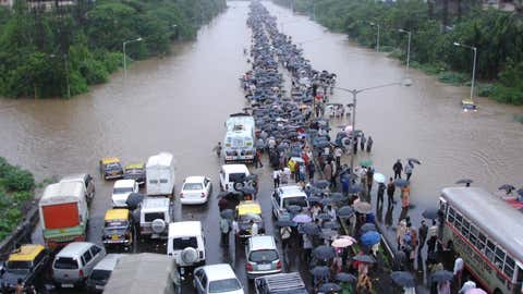
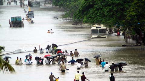
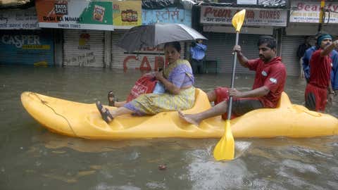
It does not feel that you are living in Mumbai if you don't wade through knee-deep water every once a while during the monsoon season. But, the 26th of July, 2005, was different!
"I distinctly remember that day. I could see the bodies floating below, as we were stuck on a railway bridge in south Mumbai," recalls a long-time South Mumbai resident.
The average monsoon rainfall across India over the four months from June 1 to September 30 is 880.6 mm. On July 26, 2005, Mumbai received more than 900 mm rainfall within a few hours!
The fury of monsoon was so intense that the financial capital was slammed with more rains on a single day than what several parts of the country receive in an entire year. The resultant floods killed over 1000 people, and the whole city came to a standstill.
Today, after one and a half decades later, the episode continues to remind the horrors of extreme weather events, as similar extremes threaten many parts of India. This year alone, Assam, Meghalaya, Bihar, West Bengal and parts of Uttar Pradesh have witnessed devastating floods, while we are not even half-way through the monsoon season yet. Just a three-hour spell of intense rains drowned several parts of Delhi last week, killing people, destroying houses and bringing the capital to a standstill.
As forecasts suggest a wetter-than-normal August, it is time to deliberate on the important question: are we prepared to manage such extremes now? Understanding the meteorology behind such episodes and assessing the current risks could offer some help.
Why did such an extreme monsoon event happen on July 26, 2005?
Experts say the processes that led to the torrential downpour on July 26, 2005, are fairly common during every monsoon season. Prof. Sridhar Balasubramanian, Associate Professor, Department of Mechanical Engineering, IIT Bombay says that a low-pressure area located over the north Bay of Bengal can always pose a danger as it pulls a lot of winds from the Arabian sea, depending on the strength.
"The resultant westerly winds activate an off-shore trough along the west coast which creates an upper-level cyclonic circulation. The moisture incursion is enhanced due to the upper-level cyclonic circulation leading to the formation of rain-bearing clouds. This is the same dynamics behind most of the heavy rain spell over Mumbai,” he explains.
A few days before July 26, 2005, a low-pressure area started to develop and it intensified into a well-marked low just before the D-day. The resultant westerly winds brought in a lot of moisture from the Arabian sea and the local convergence led to the formation of thick clouds. The system was active for almost 6-8 hours, causing intense rainfall for a sustained period. Santacruz recorded over 600 mm of rainfall between 8 am and 8 pm on that fateful day.
Are we prepared now?
Mumbai does witness one or two spells of extremely heavy rainfall of over 200 mm every monsoon season. However, what transpired in 2005 was an unfortunate blend of unfavourable weather systems within a short time. And with the changing climate, the frequency of such extreme weather events is on the rise across the country.
Last year, Mumbaikars had to endure five such extremely heavy rain days as against the norm of one such event a year. With a total rainfall of 3670 mm, Mumbai witnessed the rainiest monsoon on record in 2019.
The technology of weather forecasting has improved substantially since 2005. However, despite all the super-computing abilities and enhanced knowledge, we still struggle to accurately predict such heavy rainfall episodes over a particular locality in time. Most models, across the globe, forecast at spatial resolutions of around 10-20 km, making it difficult to predict whether a small locality like Santacruz or BKC will receive hefty rains.
With the rapidly changing climate, the scientific community warns us that it is not a matter of ‘if’, but ‘when’ that such extremes repeat. If there is one thing to be learnt from the 2005 floods, it is that the most resilient city is the one that is always prepared to face the worst possible hazard.
**
For weather, science and COVID-19 updates on the go, download The Weather Channel App (on Android and iOS store). It's free!