At a Glance
- Two tropical cyclones are active in the Arabian Sea.
- This is the first time this has happened in records dating to the early 1970s.
- A strongly positive Indian Ocean dipole and the Madden-Julian oscillation contributed.
- Only one or two Arabian Sea cyclones form each year, on average.
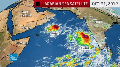
For the first time on record, two tropical cyclones are spinning at once in the Arabian Sea, one of which earlier became the strongest in that basin in 12 years.
On Wednesday, Cyclone Maha formed off the coast of western India, and is expected to gain strength over the central Arabian Sea over the next few days.
Meanwhile, Cyclone Kyarr is weakening, but still spinning to the west-northwest of Maha over the Arabian Sea well off the coast of Oman.
(INTERACTIVE: Kyarr and Maha Forecast Paths)
This is the first time multiple tropical cyclones were in progress at the same time over the Arabian Sea, according to the India Meteorological Department (IMD) and Phil Klotzbach, a tropical scientist at Colorado State University.
Only one or two tropical cyclones form each year in the Arabian Sea, on average, according to IMD records since 1891.
They typically form in spring or fall, immediately before and after the wet phase of the Asian monsoon kicks in, when hostile shearing winds relax just enough.
October and November are typically the most active months in the North Indian Ocean Basin, which includes the Arabian Sea and Bay of Bengal.
(MORE: Where Tropical Cyclone Season Peaks Twice)
Why the Duo Formed
There were two large-scale factors in play.
First, ocean temperatures over the Arabian Sea were warmer than average, generally from 0.5 to 1.5 degrees Celsius, according to a NOAA analysis.
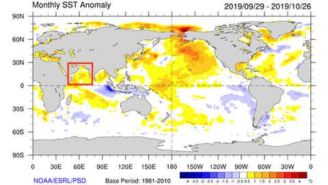
That might not sound significant, but this additional ocean heat content provides more fuel for tropical cyclones.
This is part of a sloshing of warmer and cooler ocean temperatures similar to El Niño in that part of the world known as the Indian Ocean Dipole (IOD).
Warmer water piles up in the western Indian Ocean, including the Arabian Sea, in the IOD's positive phase, making the environment more favorable for thunderstorms, one of the first ingredients needed to form a tropical cyclone.
According to Michael Ventrice, an atmospheric scientist at The Weather Company, an IBM Business, the IOD spiked in October to its third-highest positive IOD on record, second only to events in 1994 and 1997.
There was another ingredient that contributed to the tropical duo.
A large-scale atmospheric disturbance of rising and sinking motions near the equator called the Madden-Julian oscillation (MJO) ramped up by mid-October.
The MJO's rising branch of air set up over the Indian Ocean, making the atmosphere more favorable for generating thunderstorms. By the end of October, the MJO's influence in the Arabian Sea was even stronger than that of the positive IOD, Ventrice told weather.com.
Kyarr Was Most Intense in 12 Years
The first cyclone of this history-making pair was notable by itself.
Cyclone Kyarr intensified to the equivalent of a Category 4 storm on Oct. 27, with peak estimated winds of 155 mph, according to the U.S. Joint Typhoon Warning Center.
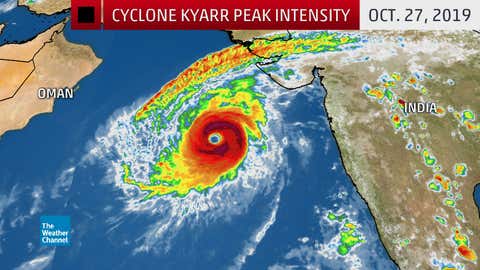
That made it the strongest Arabian Sea tropical cyclone since Gonu became a Category 5 powerhouse in early June 2007.
Kyarr remained far from the Arabian Peninsula, but it generated damaging coastal flooding along parts of the Oman coast.
The Weather Company’s primary journalistic mission is to report on breaking weather news, the environment and the importance of science to our lives. This story does not necessarily represent the position of our parent company, IBM.


