The oldest recognizable map in the world comes from Ukraine and is dated as much later than cave art, around fifteen thousand years ago. An etched mammoth tusk was unearthed along with many mammoth bones at a site called Mezhirich. The scratched lines on the tusk are not random but form a drawing or picture that is likely some kind of map. The design is made with lines, some straight, some zigzagging, presumably to denote a topographical feature. There seems to be a river at the bottom of this first map, and marks of a mountain or hill have been placed at the top. In between are more small lines that look like houses or huts. All the slashes are lines; none of them are curved in any sort of artistic way. There are also no animals and no human figures. This tusk is markedly different from any cave painting in its lack of story and figurative representation. Then, there is its straightforward presentation, which also makes it seem more map-like.
There is a clearer ancient map at the archaeologically famous site Çatalhöyük in Turkey. Çatalhöyük was a thriving city with complex cultural traditions for over two thousand years, as the several layers of buildings denote. Besides the many murals painted on the walls of that city, there is also a map dated around 6200 bc. This map is painted on a wall and is almost ten feet long. It portrays rows of houses represented as black boxes with white squares and dots that might be windows or other decorations. Their placement right next to each other resembles the layout of actual houses that archaeologists have unearthed at Çatalhöyük with the entrances typically not at ground level but through the roof. Overlooking all the houses is a mountain painted orange with black spots and lines exploding off the top. Presumably, this part of the drawing represents the volcanic mountain Hasan Dagi, which still stands over this area today, although it has not erupted in 7,500 years or so. This painting was a mural in someone’s house, just as we now hang maps as decorative art in our modern dwellings. It’s also the first map made from a bird’s-eye view, which suggests a kind of sophisticated and abstract symbolic thinking that typifies modern humans. The artist was painting close-up but also imagining his or her city from afar and from above, a special cognitive skill that is necessary for mapmaking.

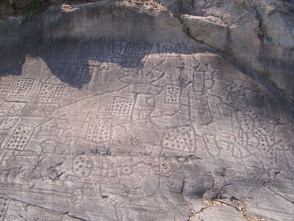
Perhaps the best-known ancient map is carved on a flat rock in the Italian Alps near the tiny city of Pescarzo. This inscribed drawing is part of a field of petroglyphs, now part of an archaeological park, where early humans spent a lot of time scratching out scenes on rocks. This one, called the Bedolina map, is of interest because it seems to be covered in images of what surely are houses, roads, fields presumably for growing, and topographical features such as streams. Superimposed on what is surely a map are some armed figures, a few animals, and one little house. This rock is thirty feet long and thirteen feet wide and dates from about 1000 bc. Scholar Christina Turconi also believes that the Beldonia map might be more than just a simple map. She acknowledges that it was carved at a time when personal property was becoming the norm and a map of a city might therefore be important, but Turconi also feels that this rock art had mystical or religious meaning and that the scene was also carved to protect the people who drew it.
Unfortunately, no one knows the mindset of the artists and cartographers making these early maps. Were these individuals simply recording some moment in time, and, if so, can we speculate why? Were they intended as mnemonic devices, to aid the creator in finding their way back or to a particular place once more? Or were they trying to communicate with others using graphics, perhaps telling a story, or giving instructions? It’s also possible that some early humans were regularly drawing maps on surfaces that haven’t survived, such as sand and dirt. These people were used to migration, following animals to kill and eat them, and mapping out a territory in their heads as they tracked the ripeness of fruits and other vegetation, and they may have made maps on temporary surfaces that have left no trace.
Those ancient humans who might have scratched directions in the sand or carved lines on wood were the first to practice the art of symbolic representation in the form of a map. From that point on, our ancestors all over the world scratched marks on walls and rocks, dipped their fingers into pigments, and gorged bones, shells, and horns to make marks of where they lived or where they were going.
Excerpted from Here Begins the Dark Sea: Venice, a Medieval Monk, and the Creation of the Most Accurate Map of the World by Meredith F. Small, published by Pegasus Books. Copyright © 2023 by Meredith F. Small. All rights reserved.

