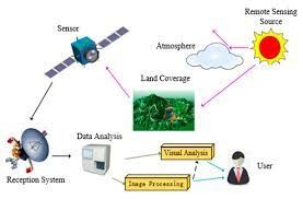
Data Image Processing in Remote Sensing
Data image processing in remote sensing is a crucial aspect of extracting valuable information from the vast amounts of data collected by remote sensing instruments, such as satellites, drones, and aerial sensors. Image processing techniques are used to enhance, analyze, and interpret remote sensing data to derive insights about the Earth's surface, its features, and changes over time. Here are some key aspects of data image processing in remote sensing:
Image Enhancement:
Image enhancement techniques are used to improve the visual quality of remote sensing images. This can include contrast stretching, histogram equalization, and filtering to make important features more discernible.
Geometric Correction:
Geometric correction or orthorectification involves rectifying images to correct for distortions caused by terrain variations, sensor angle, and satellite orbit. This ensures that images are accurately positioned on the Earth's surface.
Radiometric Correction:
Radiometric corrections adjust the brightness and contrast of remote sensing images, taking into account factors like atmospheric interference, sensor calibration, and sun angle.
Image Classification:
Image classification involves categorizing image pixels into different classes or land cover types. Supervised and unsupervised classification methods, as well as machine learning algorithms, are often used for this purpose.
Change Detection:
Change detection techniques compare images acquired at different times to identify and quantify changes in land cover, such as urban expansion, deforestation, or crop growth.
Vegetation Index Calculation:
Vegetation indices like NDVI (Normalized Difference Vegetation Index) are derived from remote sensing data to assess vegetation health and monitor crop growth.
Feature Extraction:
Remote sensing data can be processed to extract specific features like roads, buildings, water bodies, and agricultural fields. These features are essential for various applications, including urban planning and disaster management.
Mosaicking:
Mosaicking involves stitching together multiple remote sensing images to create a seamless and comprehensive image of a larger area. This is common when working with satellite imagery.
Noise Reduction:
Image processing techniques are used to reduce noise in remote sensing images, enhancing the clarity of important features.
Data Fusion:
Combining data from multiple sensors, such as optical and radar, can provide a more comprehensive view of the Earth's surface. Data fusion techniques integrate and process data from different sources.
Dimensionality Reduction:
In hyperspectral remote sensing, dimensionality reduction techniques like Principal Component Analysis (PCA) are used to reduce the number of spectral bands while retaining essential information.
Cloud and Shadow Removal:
Techniques for identifying and removing clouds and shadows from satellite imagery, which can obscure the Earth's surface, are essential for image interpretation.
Object-Based Image Analysis (OBIA):
OBIA involves segmenting remote sensing images into meaningful objects or regions and classifying them based on their characteristics. This approach is especially useful for complex land cover classification.
Visualization and Interpretation:
Once the data is processed, it is visualized and interpreted to draw meaningful insights and support decision-making in various fields, including agriculture, forestry, environmental monitoring, and urban planning.
#snsinstitutions #snsdeisgnthinkers #designthinking