The Missing Lakes of Bangalore
Last year I stumbled upon a small vintage map of Bangalore, a bit of geo-referencing and I got you an article “Is YourBangalore Office or Flat Located in a Lake of Yesteryears”. You can read the article by clicking on the link here.
Search Continues for an Old Bangalore Map
In the meanwhile I was searching for a larger vintage map of this bursting-at-the-seams city and I found one old Bartholomew & Co. map of the 1930s, which you can see below. The interesting part is the boundaries of this city which are shown in the orange and yellow thick lines on the map. The orange boundary represents the Cantonment part of Bangalore and the yellow represents the civilian areas:-

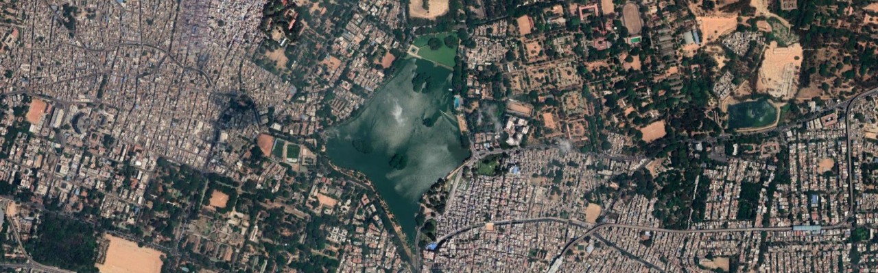
1930s Map of Bangalore showing scores of lakes. See Ulsoor lake, the North portion of the lake is now missing in the Google Image shown above it.
The Map Shows Scores of Lakes in Green
There is one very obvious inference which you can draw from this map and that is the presence of huge number of water bodies, shown in green. Now to compare the areas of these water bodies, I need to get this map into a GIS or Geographic Information System. For the uninitiated, it is a method to place the map where it belongs on earth. So I have geo-referenced this map too and then traced the water bodies, a total of more than 70 lakes in a an area of approx 150 square kilometers. These 70 odd freshwater lakes span more than 10.5 sq kms of area, a very impressive 7 percent of the city area and I have not taken into account the myriad of crisscrossing rivulets and streams which would be an additional water area.
Lakes Naturally Positioned Within Localised Watersheds
The remarkable aspect about the layout of these lakes is that these are located based on the watersheds in the area. After geo-referencing the map, I downloaded 3 second SRTM data for generating the watersheds and it was really surprising to find that such a coarse SRTM data could give very satisfactory results, please do review these watersheds and the lakes located within those various colored blobs in the image below:-

The Watersheds Generated with 3″ SRTM Data Draped over Old Bangalore Map
Just note the Ulsoor Lake so neatly divided into two watersheds and as of today the North portion of the lake has disappeared, the South portion below the Kensington Road is what is left of the Ulsoor lake today. The watersheds are kind of boundaries for the runoff water and a lake in it stores the rain water which acts like a buffer or sink. But if that lake is reclaimed and buildings constructed on top of it, the runoff water has no natural buffer and has to go over to the next lake or sink. With each lake disappearing the volume and velocity of water increases, so with almost 70 percent of lakes disappearing in the city, even nominal rains flood up the lower areas and with storm water drains clogged, the roads become the drains.
Kempegowda's Uncanny Scientific Planning for the City of Bangalore.
And here I show you with contours draped over this map for your own conclusion on the highly uncanny scientific planning of this beautiful city by the Great Kempegowda. The nature took care of Bangalore for five centuries from 15th Century to 20th Century. It was a bustling city self sufficient in agriculture through careful utilization of its lakes for rain water storage.

Watersheds and Contours draped over Old Bangalore Map :The Lakes were so precisely located within the localised watersheds.
Now see what this beautiful city of lakes has become, a concrete jungle with lakes so few that a kindergarten kid can count on his little fingers. And this we have achieved in just about half a century. Is this progress and development or rapacious ravaging of the beautiful nature?? The Google Map of Bengaluru of the exact same area as the Old map above will show the missing lakes and lay bare the naked truth of the lopsided development where nature has been the sacrificial lamb to fill up the coffers of corrupt politicians, babus and builders :-

Bangalore Map of the same area as the Old Map, where are the lakes ???
This area of Bangalore Google Map is roughly the same area as shown in the old Bartholomew map but sadly 80 percent of lakes area has vanished into thin air, well literally. The area above has just 2.25 sq kms of lakes, a huge 8 sq kms of water bed converted to land for human habitation. And it is not just the lakes which have vanished, the connecting channels have also been leveled for the roads, buildings and human habitation. Just see the Malleshwaram – Hebbal area in the old map below:-

The channels connecting to Sankey’s Reservoir from almost all the North and North West area of Bangalore.
Is Indira Nagar the Bowl of Bangalore just Waiting to be Flooded??
The North and North West Bangalore especially CV Raman Road and Sankey Tank area has the highest elevation of around 3075 to 3100 ft above sea level. The areas towards Ulsoor lake, the elevation goes down to 2940 ft and then moving towards the East Bangalore especially New Baiyyappanahalli and Vishwa Vihar, the elevation increases again to around 3000 ft. However the posh Indira Nagar, Defence Colony, BDA Colony and Domlur II Stage are all in the bowl of erstwhile Domlur Lake and going down to almost 2915ft and further South East comes the fiery Bellandur lake which has become the veritable cesspool of Bangalore.

See this South and South East Bangalore of yester-years, almost all the water bodies have disappeared in the last 80 odd years. If you check out the elevation of Vivekananda Nagar, Rajendra Nagar and Dr. Ambedkar Nagar in Google Earth, it is around 2900ft, the lowest in the South Bangalore region. So if you happen to be living in this area, any big bout of rains can result in severe runoff causing flooding of roads and the situation is going to get worse in the coming years.
Time to Take Action to Protect the Lakes, the Natural Sinks
There is no way to reverse this, we can probably manage what is left by forcing the Government not to sanction any more projects even in the outskirts of Bangalore till a proper study is conducted to determine the natural sinks and watersheds. These sinks and watersheds must be protected zones and no developmental activity should be permitted here except for facilitating the drainage of run off from the higher elevation areas.
Just in case you are interested in viewing the Old Bangalore Map draped on Google Earth and would like to see the areas which sprung up on the lake bed, just click on this link and it will download a KMZ file or Google Earth file. And if you already have Google Earth installed in your system, just a double click on the KMZ file will open up GE and also drape the map of Bangalore over it. You can analyze these old lake areas in Google Earth and if you enable the Terrain layer, in the left panel, you can actually see these lakes located in the sinks. Just browse around and see how we have played with the nature to create misery for us.
GIS Analyst and Cartographer (Self-employed)
4yThanks