
A Review of Karakoram Glacier Anomalies in High Mountains Asia
by
 , ,
, ,
Jiawei Li
1,2,
Meiping Sun
1,2,*,
Xiaojun Yao
1,2,
Hongyu Duan
1,2,
Cong Zhang
1,2,
Shuyang Wang
1,2,
Shuting Niu
1,2 and
Xin Yan
1,2 1
Department of Geography and Environment Sciences, Northwest Normal University, Lanzhou 730070, China
2
Key Laboratory of Resource Environment and Sustainable Development of Oasis, Lanzhou 730070, China
*
Author to whom correspondence should be addressed.
Water 2023, 15(18), 3215; https://doi.org/10.3390/w15183215
Submission received: 20 July 2023
/
Revised: 17 August 2023
/
Accepted: 4 September 2023
/
Published: 9 September 2023
(This article belongs to the Special Issue Assessment of Glacier Changes)
Abstract
:Influenced by global warming, glaciers in High Mountains Asia (HMA) generally show a trend of retreat and thinning, but in Karakoram, Pamir, and West Kunlun there is a trend of glacier stabilization or even a weak advance. In this study, using a bibliometric analysis, we systematically sorted the area, mass balance, and elevation changes of the glaciers in Karakoram and summarized the glacier surges in HMA. The study shows that, since the 1970s, the glaciers in the Karakoram region have experienced a weak positive mass balance, with weakly reducing area and the increasing surface elevation. The north slope of Chogori Peak and the Keltsing River Basin presented a glacier retreat rate with a fast to slow trend. The anomaly is mainly due to low summer temperatures and heavy precipitation in winter and spring in the Karakoram region. There are a large number of surging glaciers in the Karakoram Mountains, the Pamir Plateau, and the West Kunlun region in the western part of HMA, especially in the Karakoram Mountains and the Pamir Plateau, which account for more than 70% of the number of surging glaciers in the entire HMA. The glaciers in the Karakoram and Kunlun Mountains are mainly affected by the synergistic influence of various factors, such as hydrothermal conditions, atmospheric circulation, and topography. However, the glaciers in the Pamir region are mainly influenced by the thermal mechanism of the glacier surge. The glaciers in and around Karakoram are critical to the hydrological response to climate change, and glacial meltwater is an important freshwater resource in arid and semi-arid regions of South and Central Asia, as well as in western China. Therefore, changes in the Karakoram anomaly will remain a hot research topic in the future.
1. Introduction
Increased global warming has led to an overall rapid retreat trend of glaciers in High Mountains Asia (HMA) [1]. However, relevant studies have shown that glacier changes in some regions of Karakoram, Pamir, and West Kunlun in HMA are relatively stable and even have a positive balance of mass, which is more prominent in Karakoram and is referred to by academics as the Karakoram anomaly [2,3,4]. Farinotti [5] found the following two distinctive features through his study of glacial anomalies in Karakoram: the presence of a large number of surging glaciers and a glacier in a weakly positive mass balance. The Karakoram anomaly refers to the fact that in the late 20th century, when most of the glaciers in the world were retreating and thinning, the glaciers in the Karakoram region showed a stable or weakly advancing thickening trend, and a large number of glacier surge events occurred compared to other areas in HMA [3,6]. This phenomenon is also manifested to varying degrees in eastern Pamir and the western Kunlun [7,8]. The existence of a large number of surging glaciers makes the ice body collapse, blocking rivers, thus inducing the emergence of natural disasters such as glacial lake outbursts, floods, mudslides, and other natural disasters, which cause incalculable losses to human production and life [9,10,11]. The west branch of the Krajayilak Glacier on the east side of Gongge Jubei Peak in Xinjiang experienced a leap on 17 April 2015, with the glacier advancing 12 km rapidly forward, and the leaping ice body overtopping the lateral moraine ridge on the northwest side caused damage to 61 herdsmen’s houses in Aktau County, burying pastureland and killing livestock [12]. Therefore, glacier surging, a special phenomenon of glacier change, has attracted widespread attention from all walks of life.
HMA (25° N to 46° N, 67° E to 103° E) is a group of high mountains and plateaus centered on the Tibetan Plateau in the middle of Asia [13]. With an average elevation of more than 4000 m (Figure 1), HMA extends from the Tien Shan Mountains in the north to the southern edge of the Himalayas and the southern part of the Hengduan Mountains in the south, from the Tien Shan and the Pamir-Alai Mountains in the west to the eastern edge of the Tibetan Plateau to the western part of the Qilian Mountains and the Loess Plateau in the east. HMA is characterized by the Tibetan Plateau, the Pamir Plateau, the Tien Shan, the Qilian Shan, the Kunlun Shan, the Hengduan Shan, the Himalayas, the Karakoram, and the Hindu Kush [13,14,15]. HMA has the largest number of glaciers (95,500) and the largest amount of ice reserves (7021.82 × 103 km3), except for the polar regions [16,17,18,19], and glacier meltwater can supply downstream irrigation for agriculture and municipal water supply, which affects the production and life of approximately 2 billion people [20,21]. The average elevation of the Karakoram Mountains exceeds 5500 m. Its location in the northwestern part of the Tibetan Plateau makes it the second highest mountain range in the world. Its mountain range is located in the water vapor corridor of the Indian Ocean monsoon, with a westerly circulation, and precipitation is relatively abundant in the mountains [22]. At the same time, the Karakoram Mountains also developed the most intensive mountain glaciers in the Tibetan Plateau and its surrounding regions, and the glacial meltwater produced by them, as an important water resource in the upper reaches of the Indus River, provides sufficient sustenance for the local population and is of great significance for production and life [23].
Scholars’ studies of glacier changes in the Karakoram region have found that there is an abnormal mass increase in the Karakoram glaciers [3,24,25,26], but there is still no clear or consistent understanding of the process of change, the mechanism of occurrence, and the possible disaster risk. In this study, the characterization of Karakoram glacier anomalies in western HMA is systematically sorted, mainly by the glacier area, elevation change, mass balance and glacier surge, and the possible mechanisms are analyzed.
2. Data Sources and Analytical Methods
In this study, the bibliometric analysis method [27] was used, with the CNKI database and the WOS Core Collection database as the literature data sources, and the search topics were “Karakoram” and “glacier” in the title and keywords, respectively, and the search time was from 1 January 1980 to 31 June 2023. After pre-processing the search results by de-weighting, limiting the types (including dissertations, journal articles, articles, and review articles) and removing significantly irrelevant entries, 67 and 876 documents were obtained from the CNKI and WOS databases, respectively. Then, a knowledge map was drawn with CiteSpace 6.1.R2 software [28] to analyze the main research hotspots in the field of glaciers in the Karakoram region at home and abroad in the past 40 years. Keyword co-occurrence refers to the simultaneous appearance of two or more keywords in a text, which reveals the intrinsic relevance of the content of academic research in a certain field and the microstructure of the subject area by describing the association and combination of keywords [29]. The results of keyword co-occurrence in the CNKI database show that, in addition to the subject term “Karakoram”, the terms “China–Pakistan highway”, “glacier”, “surge glacier”, “glacial change”, “Pamir”, “Himalaya”, “climate change”, “surface elevation”, “remote sensing”, “mechanisms”, “temperature “, “precipitation”, “geohazards”, “mudslides”, and “moraines” are the most frequently used keywords. The WOS database shows that, in addition to the subject term “Karakoram”, the terms “climate change”, “glaciers mass balance”, “karakoram himalaya”, “precipitation”, “upper indus basin”, “region”, “remote sensing”, “debris covered glaciers”, “variable”, “runoff”, “temperature”, “glacier area”, “glacier elevation changes”, “high mountain area” “glacier surge”, “karakoram anomaly”, and “summer monsoon” are the most frequently used keywords. The results of keyword co-occurrence after combining the data from the CNKI and WOS databases are shown in Figure 2. The above keywords with high frequency represent the focuses of the published literature, indicating that remote sensing-based research on Karakoram glaciers in the context of climate change, glacier changes (area, material balance, elevation), the mechanism of the Karakoram anomaly, and downstream geologic hazards caused by glacier surge have been the focus of domestic and foreign scholars in the field of glacier research in recent years.
Keyword clustering refers to the clustering of closely related keywords into one group to observe the formation of research clusters in a certain technology or discipline, which is a further research method based on the co-occurrence of keywords. In the keyword clustering map, “climate change”, “karakoram glacier change”, “mechanisms of climate change”, “mechanisms of influence”, “elevation and surge”, “area and mass balance”, “basin”, “temperature and precipitation”, and other clusters appear almost as frequently as the keywords, which reflects the fact that in the context of climate change, glacier area change, glacier mass balance change, glacier elevation change, glacier surge identification, and causes and mechanisms of temperature and precipitation are the key directions in the field of glacier research in Karakoram (Figure 3). Based on this study, we systematically sort the area, elevation, mass balance, and glacier surge identification and causes of the Karakoram glacier and analyze the impact mechanism of glacier change causes.
In this study, three sets of data were used for the glacier elevation change [30], glacier mass balance change [31], and the number of surge glaciers in HMA [32]. The elevation and mass balance data processed by ArcGIS 10.8 software were 1° × 1° grid point data, and the number by category option under the Multiple Attributes of the Symbol System in the Layer Attribute tool of ArcGIS was selected to classify the elevation and mass balance data into 35 categories and 30 categories, and the rate of change of elevation in HMA from 2000 to 2019 and the evolutionary trend of mass balance in HMA from 2000 to 2016 were finally obtained. The surging glacier was processed using ArcGIS is the dataset of the surging glacier in HMA from 1972 to 2019, which includes a total of five data files, and three data files are used in this study: (1) STG_HMA.shp is the data file of the HMA that had a surging event in the study period; (2) HMA_regionshape.shp is the vector data of subregions in HMA that had surging events during the study period; and (3) Attributes of STG.xlsx is the attribute information file of the surging glaciers in HMA that had surging events during the study period, which contains the basis for judging the surging events. Finally, the distribution of glacier surging in HMA from 1972 to 2019 is obtained.
3. Changes in the Area of Karakoram Glaciers
Glacier area is a key parameter for calculating the mass balance of glaciers and the amount of glacier water resources, an important indicator of the development of glaciers in a region, and one of the most direct responses to climate change and the easiest to observe covariates. Early glacier area monitoring was based on field measurements in the field, which was labor-intensive and material-intensive; after that, the Global Positioning System (GPS) appeared, which was not able to measure on a large scale. After the emergence of aerial photogrammetry, the glacier boundaries were mapped manually and digitally and was greatly affected by the adverse climatic conditions. Currently, the methods for the study of glacier area (glacier boundary) mainly include manual visual interpretation, ratio threshold method [33,34,35,36,37], supervised/unsupervised classification, snow cover index threshold method and water body index, normalized snow cover index method, and ratio threshold method combined with visual interpretation [38]. Among them, the band ratio thresholding method based on multispectral remote sensing images combined with manual visual interpretation has the highest accuracy in extracting glacier boundaries.
A study (Table 1) by Shean et al. [39] of glacier area in HMA revealed a generalized state of increased retreat. Kääb et al. [26] found that glaciers in western China are mostly in a retreating state with reduced area. The glacier on the north slope of Chogori Peak, the highest peak in the Karakoram Mountains, retreated at a faster to slower rate during 1978–2014 [40], with a decrease of 53.37 km2 and an annual rate of change of the glacier area of −0.19% a−1; the change in the glacier area in the Nubra watershed and the average annual rate of change from 1993–2015, respectively, were −103.24 km2 and −0.2% a−1 [33]. Xu et al. [34] used Landsat MSS, TM, ETM+, and OLI remote sensing images, extracted glacier boundaries by computer-aided classification and visual interpretation of remote sensing images, and analyzed the advancing and retreating changes of the glaciers of the Keleqing River Basin of the Karakoram Mountains during the period 1978–2015 and found that the area of the glaciers in the Keleqing River Basin decreased from 1821.70 to 1675.92 km2, a decrease of 145.78 km2, and the average annual retreat rate was 0.22% a−1, and the glacier ablation rate was low. Li et al. [35] studied the Shyok watershed in the Karakoram Mountains with an average annual rate of change of (−0.05% ± 0.20)% a−1 over the last 20 years, and a weak area reduction occurred. Zhang et al. [36] studied the Gilgit River watershed in the Western Karakoram region from 1993 to 2016 and found that the glacier area over the last 20 years decreased by (45.82 ± 9.07) km2, with an average annual rate of change of (0.18% ± 0.03)% a−1. Wang et al. [37] studied the Shigar basin in the central Karakoram Mountains and found that the glacier area decreased by (2.67 ± 14.79) km2, with an average annual decrease of (0.00% ± 0.02)% a−1 over the last 20 years.
It can be seen from the above studies that, since the 1970s until the early 21st century, the Nubra, Shyok, Gilgit, Shigar, and Kelching river basins in Karakoram have experienced a weak decrease in glacier area change, with the average annual rate of change in the area being less than −0.25% a−1 in the face of an upsurge in mean annual temperatures. Some studies have shown that the glacier retreat rate on the north slope of Chogori Peak in the Karakoram Mountains and the Kelqing River basin showed a trend from fast to slow from 1978 to 2015 [34,40]. This indicates that the Karakoram glaciers have shown a stable state since the 1970s.
4. Changes in Elevation of the Karakoram Glacier
Glacier elevation change can be used to accurately estimate the amount of glacier accumulation loss and glacier elevation and area change can be used to obtain the mass balance change; glacier elevation is also an extremely important parameters. Glacier elevation change research methods mainly include field survey methods, satellite-carried LiDAR measurements, synthetic aperture radar measurements, and optical stereo image pair measurements. Early monitoring methods were manual flower pole measurements, which were accurate and continuous and were greatly affected by the terrain [26,42]. Elevation information was obtained directly using mainly altimetry data (ICESat-1&2, Gravity Satellite Data, CryoSat-2) and DEM data such as Digital Elevation Models (Shuttle Radar Topography Mission Digital Elevation Model (SRTM DEM), Advanced Spaceborne Thermal Emission, and Reflection Radiometer Global Digital Elevation Model (ASTER GDEM), TerraSAR-X and TanDEM-X), supported by remote sensing by satellite technology [26,42]. Each method has its own advantages and disadvantages, as shown in Table 2.
Shen et al. [42] studied the rate of glacier elevation change in HMA from 2003 to 2020 based on ICESat-1&2 data and found that the rates of glacier elevation change from 2003 to 2008 and from 2003 to 2020 were (−0.21 ± 0.12) m.a−1 and (−0.26 ± 0.11) m.a−1, respectively, with glacier ablation becoming more and more rapid. Kääb et al. [26] estimated the glacier elevation change in the Karakoram Mountains from 2003 to 2008 based on SRTM DEM and ICESat data: (+0.41 ± 0. 04) m.a−1 in winter and (−0.07 ± 0.04) m.a−1 in fall, with a cumulative state on the annual scale.
The study showed that the rate of glacier elevation lowering in Pamir and Hindu Kush showed a slowing down trend [42], and the rate of glacier elevation change in Pamir and western Kunlun was −0.22 m.a−1 and −0.27 m.a−1 in 2003–2008, and the rate of glacier elevation change in the 2003–2020 period was slowed down to −0.13 m.a−1 and −0.17 m.a−1, respectively. Rankl et al. [43] found that glacier elevation varied from −0.09 m.a−1 to 0.21 m.a−1 from 2000 to 2012 in Karakoram. The rate of change of glacier elevation in most areas of HMA in the context of global warming shows a trend of retreat and thinning, while glaciers in the Karakoram, Pamir, and West Kunlun regions show a trend of stabilization or even weak thickening. Through the average glacier elevation change rate in HMA from 2000–2019 (Figure 4), the glacier elevation showed different degrees of thinning and thickening, and the rate of glacier elevation change in the Karakoram region was positive. Glaciers in the Karakoram region are in an increasing state.
5. Changes in the Mass Balance of the Karakoram Glacier
Relevant studies have shown that the mass balance in HMA is generally in negative equilibrium [30,31,44], but the mass balance of glaciers in localized areas such as the Karakoram [37], Pamir, West Kunlun, and Kunlun Mountains is close to equilibrium or in positive equilibrium. Glacier mass balance (glacier volume) research methods mainly include traditional geodetic methods (flower pole method), statistical formula method (glacier area-volume relationship ratio), glacier topographic measurements (topographic observation, stereophotogrammetry, radar interferometry, differential GPS measurements), and remote sensing monitoring methods (multi-source DEM observation of glacier thickness volume change, bottoming radar thickness measurement) [26,37,43]. Among them, geodetic methods (accurate measurement, but high cost and influenced by topographic conditions) are used, but more studies use glacier topography (low cost and wide coverage) [24,45,46,47,48]. Overall glacier elevation and glacier mass balance change studies have used one or more types of elevation data to build digital surface models and then analyze the differences between the models.
The anomalous features in the Karakoram region mainly include the presence of a large number of surging glaciers as well as a weak positive mass balance, and Figure 5 shows the change in the mass balance of glaciers in the 1° × 1° grid in HMA from 2000–2016 [31] (single glaciers with glacier area less than 2 km2 were not counted in the data), and the glacier mass balance in most of the other regions in HMA was in a negative equilibrium in the period 2000–2016, except for the Karakoram region.
Gardelle et al. [24] revealed that the mass balance in the Karakoram Mountains was (+0.11 ± 0.22) m w.e.a−1 and (+0.10 ± 0.16) m w.e.a−1 in 1999–2008 and 1999–2011, respectively, and that the Karakoram glaciers showed a weak positive mass balance. Wang et al. [37] showed that the change in mass balance in the Shigar watershed in the central Karakoram Mountains from 2000 to 2016 was (−0.00 ± 0.03) m w.e.a−1. Kääb et al. [26] found that glaciers in the Karakoram region were in negative mass balance from 2003 to 2008 based on SRTM DEM and ICESat data. Lin et al. [45] showed that the mass balance of the Siachen Glacier in Karakorum from 2000–2014 was (−0.11 ± 0.24) m w.e.a−1. Rankl and Braun [43] revealed a mass balance of (−0.08 ± 0.10) m w.e.a−1 for 2000–2012 in the central Karakoram. Agarwal et al. [46] showed that the mass balance of the Siachen Glacier (East Karakoram) was (−0.03 ± 0.21) m w.e.a−1 for 1999–2007.
The above study of the balance of matter in the Karakoram region found a weak positive balance of matter, which is quite different from the changes in the balance of matter in most parts of HMA, emphasizing the phenomenon of the Karakoram anomaly (Table 3). Combined with the above summary, it can be shown that the Karakoram anomaly can be traced back to the 1970s. Combined with previous research, it is concluded that from the 1970s to the present, the Karakoram glacier has been, on the whole, in a state of near-equilibrium.
6. Number of Glacier Surges in Karakoram
Glacier surge is a special glacier movement phenomenon in which a glacier periodically undergoes rapid movement in a relatively short period of time (2–3a) [50], and the most distinctive feature of surging glacier identification is the rapid advance of the glacier terminus [51]. The basis for the identification of glacier surges mainly includes the following: changes in glacier end position, changes in glacier surface (elevation, features, flow velocity), and glacier end shape [32,52,53,54,55,56,57,58,59,60,61,62,63,64]. Surging glaciers occur in most parts of the globe, mainly in the Yukon region of Canada, Alaska in the United States [65], Svalbard and East Greenland in Norway [66], and in HMA, in Karakorum [67,68,69,70,71], western Kunlun [63,72,73], and the Pamirs [52,53,74]. Small portions of surge glaciers are also present in HMA, such as Tian Shan [54,55], Tanggula Shan [56,75,76], Hindu Kush [32], and the interior of the Tibetan Plateau [12,56].
Lv et al. [32] confirmed 362 surging glaciers in HMA from 1972 to 2019 by aligning and differencing two batches of digital elevation model (DEM) data covering all of HMA, combined with other glacier surface elevation change data as well as historical optical remote sensing imagery from the 1970s to 2019. Figure 6 is taken from a dataset of surging glaciers in HMA based on elevation changes and remote sensing imagery [32] and was generated using three main data types: optical remote sensing imagery, DEM, and glacier cataloging data. Optical remote sensing images: for glacier edge contour extraction and image verification of historical surge events; DEM: for glacier surface elevation information and elevation change extraction; glacier cataloging data: for glacier boundary reference and DEM alignment assistance. The website of the data service system is (http://dx.doi.org/10.11922/sciencedb.00901). Data accessed 1 June 2023.
Based on China’s second glacier inventory and Randolph Glacier Inventory Version 6.0 (RGI V6.0) glacier inventory data (Table 4), Zhou identified a total of 244 glaciers based on Landsat TM/ETM+/OLI remote sensing imagery from 1986 to 2021 while comparing the changes in glacier end position, glacier surface features and their elevation changes, glacier flow rate changes, and the basis of the shape of the end of the glaciers in HMA surging glaciers [61]. Bhambri et al. [59] identified 172 surging glaciers in the Karakoram region from 1840 to 2017 based on fieldwork data and Landsat and ASTER satellite data by discriminating changes in glacier ends, surface flow rates, and surface features. Goerlich et al. [60] identified 202 glaciers in the Pamir region that appeared to be the basis of glacier end advance and surface elevation change discrimination from 1960 to 2018 through Landsat, Corona KH-4, Hexagon KH-9, SRTM, AW3D30, ASTER GDEM, and TanDEM-X data. Yasuda and Furuya [72] identified nine surging glaciers in the Kunlun Mountain region from 1972 to 1992 by studying the changes in glacier terminal and glacier surface flow velocity in part of the Kunlun Mountain region. In terms of the number of surging glaciers in each mountain range, the highest number of surging glaciers in HMA is distributed in the Karakorum and Pamir regions. Copland et al. [60], based on the literature, Landsat MSS/ETM+, and ASTER data, identified a total of 90 glaciers in the Karakoram Mountains that had surged from 1960 to 2011 by using surface features and end changes as the basis for the identification of surging glaciers. Rankl et al. [77] identified a total of 101 surging glaciers in the Karakoram Mountains from 1976 to 2012 based on Landsat and SAR satellite imagery data using the glacier surface flow rate and end position as the basis for the identification of surging glaciers. Kotlyakov et al. [74] identified a total of 215 glaciers that surged in Pamir from 1972 to 2006 based on Resurs-F satellites, Landsat, and ASTER data through glacier surface features, glacier surface flow velocity, and end position identification basis. Goerlich et al. [52] used the same method as Kotlyakov et al. to identify a total of 206 glaciers that have surged from 1960s to 2018 based on Landsat, Corona and Hexagon, SRTM DEM, ASTER GDEM, and AW3D30 DEM data. Lv et al. [32] identified a total of 362 active glaciers in HMA based on elevation changes and remote sensing images, while the active glaciers in the Pamir and Karakoram regions accounted for 37% and 35% of the total number of active glaciers in HMA, respectively, which confirmed the existence of a large number of active glaciers in the Karakoram Anomaly.
7. Mechanisms of Glacial Anomalies in the Karakoram Region
Currently, scholars investigating the causes of Karakoram anomalies mainly explain them in terms of climate change sensitivity (temperature and precipitation) and climate change factors, as well as characteristics of the glacier’s own properties. Forsythe et al. [79], on the study of climatic drivers of glacier mass balance in Karakoram, found that low summer temperatures and summer temperatures below 0 °C were the main influences on glacier anomalies in Karakoram. The average elevation of the glaciers in the Karakoram region is high, and for most of the year precipitation occurs in the form of snowfall, resulting in increased annual accumulation. Scholars have also explored the mechanism of Karakoram glacier anomalies from the perspective of atmospheric circulation and local circulation. Kapnick et al. [80] found that due to the influence of the westerly winds, which makes the winter precipitation in the Karakoram region higher than the summer precipitation, the winter snowfall shows an increasing trend, which is mainly due to the enhancement of the westerly circulation and the intensity of precipitation, as well as an increase in the frequency of the joint cause, mainly because of the Indian monsoon and the mid-latitude westerly belt interaction complex. Forsythe et al. [79] proposed that there is a complex and strong local circulation system in the Karakoram region, known as the Karakoram vortex; this vortex comes mainly from the bottom of the convergence of the upper level of the convergence of the anomalous upward motion corresponding to the dispersion, due to the snow and ice cover, resulting in the local circulation system affecting the troposphere atmosphere and the ground atmosphere exchange process. With the Karakoram region glaciers being at higher elevations, the climate conditions are more severe, resulting in less observational data that can be used from stations in the region, and therefore in precipitation trend estimation there still exists a certain degree of uncertainty; in general, most scholars still think that the total precipitation in the Karakoram region is increased. Cannon et al. [81] found that the main climatic factor for the slowing down of glacier retreat in the Karakoram region is due to the increased precipitation, which alters the glacier radiation conditions, leading to a decrease in net shortwave radiation, which inhibits glacier ablation.
7.1. Hydrothermal Conditions
Temperature and precipitation as key influences affect glacier accumulation and ablation, which together determine the nature, evolution, and development of glaciers [82]. HMA has experienced rapid warming since the 1980s at rates not seen in the last two millennia [1,83]. Hewitt et al. [84], in their study of Karakoram glaciers, found that one third of the annual snowfall was summer snowfall and the other two thirds occurred in winter.
Some scholars have shown that the average annual temperature in HMA has increased by approximately 0.44 °C per decade over the last four decades from 1979 to 2020 [85,86,87], a value much higher than the average global temperature warming rate of 0.19 °C per decade [2]. Li et al. [88] found that HMA showed a clear upward trend in temperature during 1961–2017, with a warming rate of 0.323 °C (10a)−1. There are obvious seasonal and spatial differences in climate warming in the high mountainous regions of Asia, and Yao et al. [89] found that the rate of winter warming (0.46 °C) in the high mountainous regions of Asia was almost twice as high as the rate of summer warming (0.26 °C) in a study of the change in temperature from 1960 to 2013. It has also been found that the rate of climate warming in the high mountainous regions of Asia increases with elevation and also increases spatially from south to north [87,90,91,92]. This background of climatic conditions, with low summer temperatures and high precipitation in spring and winter, is one of the main reasons for its anomalies.
7.2. Atmospheric Circulation
HMA is located at the confluence of high mountain systems and is characterized by special conditions of geography and topography, spanning north, south, east, and west, allowing the region to form the largest modern glacial area in the low and middle latitudes [93]. HMA is controlled and influenced by a variety of atmospheric circulations. The southern part is mainly influenced by the Indian monsoon, the western and northwestern parts are mainly influenced by the westerly circulation, the eastern and southeastern parts are mainly influenced by the East Asian monsoon, and the central part is mainly influenced by the continental monsoon [94]. It is also influenced by the plateau monsoon, which is formed by the different cold and heat sources of the local microcirculation in winter and summer on the Tibetan Plateau. The dominant weather system in the Karakoram Mountains varies from season to season. In winter it is affected by the westerly circulation and cyclonic storms; high winds, low temperatures, and snowfall can occur under the combined effect of the two, and the low-pressure trough is stronger in the winter, which makes precipitation from the westerly circulation water vapor produce the most precipitation in the spring and winter [95,96]. The summer season is mainly influenced by the Indian monsoon, while the two climate systems mentioned above are also influenced by the thermal low pressure of the Tibetan Plateau [97].The increase in precipitation in the Karakoram region is due to the strengthening of the westerly circulation, and the increase in precipitation has made the Karakoram region the region with the smallest rate of glacier shrinkage in the whole of HMA.
7.3. Surface Moraine Thickness
Glacial surface moraine debris is widely distributed in the Karakoram region, accounting for approximately 18–22% of the glacial area [6,98], a proportion that is about twice as high as that in the Himalayan region [99]. In addition to obtaining cover from the ice bed through planing and exhumation during glacier movement, gravity slides, ice/snow avalanches, and freezing and thawing can result in the avalanche of rock debris material from periglacial slopes to the surface of the glacier or into the interior of the glacier [100,101,102,103]. Lejeune [104] and Collier [105] studied the debris cover on the surface of glaciers and the process of glacial melting. Scherler et al. [98] found that surface moraine cover is more prevalent in glaciers in the Karakoram region, and the presence of a large amount of debris cover will have a great potential impact on the ablation of Karakoram glaciers. Many scholars have shown that the debris surface moraine cover has a critical value; when the thickness of the surface moraine is thin, the existence of the surface moraine accelerates the glacier ablation, and when the thickness exceeds the critical value, it will inhibit the glacier ablation [106,107,108,109,110,111,112]. A field study by Fujii [113] found that, compared with the natural snow surface, the glacier ablation rate under a thin debris layer is accelerated, and glacier ablation is slowed down under a thick debris layer; the critical thickness of the debris layer is 1.6 cm, and the glacier ablation rate is maximum under a 0.5 cm-thick debris cover. Østrem [106] found that when the thickness of surface moraine is approximately 2 cm, the rate of ablation of the bare ice area is almost the same as the rate of glacier ablation under surface moraine. When the thickness of surface moraine is approximately 2 cm, the ablation rate of the bare ice area and the ablation rate of the glacier under the surface moraine are almost the same; a surface moraine thickness of approximately 2 cm is called the critical thickness. Liu et al. [114], while studying the Himalayan Jombo glacier, found that the thickness of the surface moraine decreased with elevation, and the surface moraine thickness of 5 cm at the average ablation compared with the bare ice area increased by 67.0%. The glacier ablation rate decreases with increasing surface moraine thickness when the surface moraine thickness is >8.5 cm [114]. Mattson et al. [112], in Himalayan region Rakhiot glacier observation experiments, found that when the surface moraine thickness was approximately 1 cm, the amount of glacier ablation was below the maximum; 3 cm of surface moraine thickness is called the critical thickness. Some scholars have found that when the thickness of surface moraine cover exceeds 2 m, the glacial ablation of its underlying layers is basically at a standstill [106,112,115].
In summary, the influence of glacier surface moraine cover on the accumulation and ablation of glaciers due to the distribution of surface moraine thickness and the proportion of surface moraine cover in different glacier areas in HMA varies greatly. Some scholars studying the Karakoram Mountains region regarding different typical glacier area field ablation observations found that the region of the surface moraine cover under the glacier ablation is mainly inhibited [105,115,116], which may be caused by the Karakoram glacier anomalies, or the anomalies may be part of the reason. Mihalcea et al. [115] studied the Baltoro Glacier in Karakoram and found that the average ablation of glaciers in the surface moraine-covered area of this glacier decreased by approximately 22.0%, relative to the bare ice area. Muhammad et al. [116] found that a thin surface moraine debris layer of 0.5 cm did not contribute to glacier ablation compared to clean ice.
The thickness change of the glacier is the main basis for judging the surface moraine cover on the accumulation of ablation of the lower glacier. When the thickness of the surface moraine cover is thin, the surface moraine layer is subjected to heat absorption, and there will be a large part of the heat efficiently transmitted to the lower overlying ice. This condition will accelerate the glacier ablation, resulting in the enhancement of the loss of glacier material as well as an increase in the runoff of the glacier meltwater, which leads to the glacier on the formation of climate change, a positive feedback effect [117,118]. When the thickness of the surface moraine cover is thicker, the heat absorbed by the surface moraine cover is higher, which will reduce the heat reaching the lower overlying ice layer. This situation inhibits the glacier ablation, which leads to a slowing down of the loss of glacier material as well as a reduction in the glacier meltwater runoff, which ultimately leads to the glacier on the formation of climate change, a negative feedback effect [117,118].
7.4. Topographical Impacts
7.4.1. Influence of Glacier Elevation and Slope Direction
Iturrizaga [119] argued that glaciers in the Karakoram region are larger in size and higher in elevation than subcontinental glaciers, which are insensitive to climate change and have a significant hysteresis effect on temperature change. The Indian monsoon provides a large amount of precipitation for the Himalayan region, but most of the water vapor is condensed at heights below 4000 m above sea level to cause rain, and the influence of monsoon water vapor decreases from east to west along the Himalayas, which makes the aridity of high-altitude glacial watersheds significantly worse [64]. Compared with monsoon water vapor, westerly water vapor can reach higher altitudes [120], and maximum precipitation occurs between 5000 m and 6000 m above sea level [6]. The glaciers in the Karakoram region are of the westerly-dominated winter precipitation type, with freeze–thaw cycles occurring between 4000 m and 6000 m above sea level, and because the region is surrounded by high mountains (Hindu Kush, Tien Shan, and Karakoram Mountains), it has a typical arid and semi-arid alpine climate [121]. The unique geomorphic units make the region highly sensitive to the effects of external factors and important feedbacks.
The different orientations of glaciers can also have an effect on glacier ablation. Muhammad et al. [116] studied the melt rates of three glaciers in the Karakoram region facing east, south, and north and found that ice without debris melted faster than ice covered with debris, with south-facing glaciers experiencing the greatest ablation (an average of a 25% increase), and north- and east-facing glaciers displaying almost the same rate of ablation.
7.4.2. Surging Mechanism
There is no systematic explanation for the mechanism of glacier surging, but most scholars generally believe that the root cause of glacier surging is the instability of glacier dynamics [122,123]. Robin [124] suggests that glacier surging is promoted by a combination of water film, temperature, and stress instability. Clarke et al. [125] suggest that a portion of the glacier changes from extensional to compressive flow, leading to glacier stressivity. Meier et al. [50] suggested that, at the bottom of the boundary between stagnant and surge ice, surging occurs when the shear stress reaches a certain critical value, which leads to rapid downstream movement of the ice body. In addition, glacial meltwater is also seen as the main cause of glacial surging.
Thermal and hydrological mechanism control is the main reason for the current control mechanism explanation of surging glaciers [126,127,128]. Clarke et al. [125] suggested that thermal mechanism control due to the change of temperature field at the bottom leads to the increase of porosity and deformation of the under-ice sedimentary layer, which triggers glacier surging, and the glacier under the control of thermal mechanisms is independent of seasonal time. It can begin and end in any season, and this kind of glacier reaches the peak of the surging a few years after the beginning of the surging, and the decelerating phase can also last up to a few years [125]. Some studies have shown that the main driver for triggering glacier surges under the control of hydrological regimes is the change from centralized to distributed drainage systems at the bottom of the glacier, and that surges under the control of hydrological regimes have faster processes of initiation and termination of surges, which usually begin in winter with small amounts of glacial meltwater, resulting in poorly drained and poorly distributed subglacial hydrological systems, and ultimately end in summer, when a large amount of meltwater reestablishes effective drainage channels [129,130]. Increased subglacial hydrostatic pressure is the ultimate cause of both the thermal and hydrologic mechanisms, with increased pressure enhancing sliding at the base of the glacier.
The relationship between surging glaciers and climate change has also been studied by several scholars. Striberger et al. [131] suggested that changes in the mass balance of Eyjabakkajökull Glacier led to a climate-driven glacier surge cycle, and Gao et al. [132] found that anomalies in climate change in the Bukhadasaka Peak area led to glacier advance.
Different scholars studying the Karakoram mountain glacier surge mechanism have different views. Quincey et al. [69] and Hewitt et al. [70] believe that, regarding the surge of the Karakoram glacier, the dominant mechanism is a thermodynamic mechanism; the bottom of the glacier is in a state of pressure and melting caused by an increase in the amount of accumulation. Copland et al. [5] and Farinotti et al. [60] suggested that the main cause of the Karakoram glacier surge was the change in hydrological conditions. However, Quincey et al., in a subsequent observational study, changed the previous simple thermodynamic mechanism, arguing that the Karakoram surge is subject to a combination of hydrologic and thermal mechanisms [122]. Iturrizaga et al. [133] and Lovell et al. [134] suggested that the high altitude and complex topographic and climatic context was responsible for the occurrence of surge glaciers and advancing glaciers in the Karakoram Mountains. In summary, Karakoram surge glaciers are subject to a variety of mechanisms.
Li et al. [135] concluded that the North Kyzkurgan glacier in Pamir is controlled by a thermodynamic mechanism and that the glacier surges are due to the increasing amount of material in the accumulation zone, leading to a pressure melting point at the bottom of the glacier. Zhang et al. [51] concluded that the East Pamir glacier, coded 5Y663L0023, is more likely to be affected by thermodynamic mechanisms, and that the main reason for the alteration of hydrological conditions within the ice is the increase in ice meltwater and liquid precipitation. Shangguan et al. [12] and Zhang et al. [136] suggested that the East Pamir Kraya Yilak Glacier is influenced by thermodynamic mechanisms. The characteristics of the glaciers in the eastern and western parts of Pamir are different, and their control mechanisms are also different. In summary, the glacier movement in the Pamir region is mainly influenced by the thermal mechanism.
Yasuda et al. [63] suggested that the combined effect of thermal and hydrological mechanisms caused glacier surging in the West Kunlun region, and Mackintosh et al. [137] suggested that warmer temperatures led to an increase in glacier meltwater in the West Kunlun region, resulting in a large amount of meltwater entering into and under the ice, along with the crevasses, which triggered glacier surging. Frappét [138] attributed the surging of the West Kunlun glacier to glacial ablation pressure and frictional heat-generating processes that melted the glaciers in the region, producing large quantities of subglacial meltwater, which led to the surging of the glacier. Gao et al. [132] suggested that glacier advance in the Buka Darshan Peak area of East Kunlun may be subject to a combination of thermal and hydrological mechanisms. Combined with existing research, synthesis analysis shows that, in the Kunlun Mountain region, the thermal mechanism and the hydrological mechanism have a joint role in glacier surge.
The synthesis of the above studies found that the mechanism of glacier surging in HMA is largely influenced by climatic conditions, but also by the joint effect of several other factors (Table 5). Taken together, the Karakoram and Kunlun Mountains surging glaciers are mainly affected by the synergistic effects of various factors, such as hydrothermal conditions, atmospheric circulation, and topography, and the glacier surging in the Pamir region is mainly affected by the thermal mechanism.
8. Conclusions and Discussion
In this study, by investigating the phenomenon of the Karakoram anomaly in terms of the area, elevation, and mass balance of the glaciers in HMA and the Karakoram, Kunlun, and Pamir Mountains, where a large number of surging glaciers exist, studying the mechanism of the surge, and by the systematic sorting of studies of Karakoram glacier anomalies in HMA from domestic and foreign scholars, we can draw the following conclusions.
The glacier area in the Karakoram region is weakly decreasing, the glacier elevation thickness is weakly increasing, and there is a stable or weakly positive mass balance. The main reason for this phenomenon is the lower summer temperatures in the region caused by global warming and the higher precipitation in the region in spring and winter under the action of westerly wind circulation. Temperature determines the ablation of glaciers; precipitation determines the accumulation of glaciers; and their combination together determines the nature, development, and evolution of glaciers. At the same time, regarding the hydrological mechanism and the thermal mechanism under the joint action of the Karakorum region, there are a large number of glacial surges caused by this main mechanism. It should be noted that when a glacier surges, its bottom appears to slip, whether forward or backward, and the glacier is in a state of imbalance. However, in this region, due to the mechanism of temperature and precipitation anomalies, the glacier as a whole has a stable or slightly increased mass balance. The combination of these anomalies is referred to as the Karakoram anomaly (Figure 7).
1. According to the existing literature, statistics have found that, since the 1970s, the Karakoram region appears to have had a weak positive mass balance, the average glacier elevation change rate is an increasing trend, and the glacier area appears to have a weak decrease This phenomenon appears to be mainly due to the influence of the westerly winds, so that, in the Karakoram region in winter, precipitation is higher than in the summer. The snowfall in winter showed an increasing trend compared to the summer, which is mainly due to the Indian monsoon and the interactions of the mid-latitude westerly zone. This results in low summer temperatures and high rainfall in spring and winter in the Karakoram. At the same time, the thinness of the surface moraine will also have an impact on the accumulation and ablation of glaciers.
2. Through the documentation of the number of surging glaciers in HMA, it was found that there are surging glaciers in the Karakoram Mountains, the Pamir Plateau, the Tien Shan, the Kunlun Mountains, the Himalayas, the Tanggula Mountains, the Qilian Mountains, the Anyemaqen Mountains, the Nyainqentanglha Mountains, the Hindu Kush Mountains, and the inner regions of the Tibetan Plateau. In particular, the number of surging glaciers in the Karakoram Mountains and the Pamir Plateau accounts for more than 70% of the total number of surging glaciers in HMA. It should be noted that when glaciers surge, a single glacier is in a state of disequilibrium, but under the combined effect of temperature and precipitation, the mass balance of the glaciers in the Karakoram region tends to stabilize or have a weakly positive balance.
3. The existence of a large number of surging glaciers can be a serious threat to both humans and nature, so it is particularly important to clarify the mechanism of glacier surging in the Karakoram, Pamir, and Kunlun Mountains. In the Karakoram Mountains and the Kunlun Mountains, surge glaciers are caused mainly by water, heat mechanisms, climatic factors, and topographic conditions, as well as a variety of factors such as common control. Pamir region glacier surging is caused mainly by the thermal mechanism, while in its east and west regions the mechanism is affected differently.
There is obvious spatial variability in glacier changes in the Karakoram Mountains, and glacier advance and surging are the main manifestations of its glacier change anomalies. Glacier changes are mainly determined through positional monitoring, field expeditions, and the comparison of remote sensing or aerial data at different times. The variable climate and complex topography of HMA make glacier monitoring possible only on a very small number of easily accessible glaciers. All studies on glacier elevation changes in HMA have focused mainly on interannual changes, while studies on monthly and seasonal changes in glacier elevation show that they are still surging, mainly due to the low temporal resolution of DEM data. Most studies of glacier surface elevation change base their inferences of monthly, seasonal glacier elevation change on relationships with temperature precipitation, rather than directly extracting glacier elevation information from satellite observations. As far as we can see, research on different types of glaciers in the Karakoram region, especially the surface elevation changes and mass balance of glaciers in different states of motion, is relatively scarce. The main reason for this is due to the relatively high elevation of the glaciers in this region; due to extremely inconvenient transportation, the climatic conditions, and the environment, it is difficult to carry out the implementation of large-scale glacier meteorology and other field scientific research work. The above-mentioned unfavorable factors mean that the majority of research is still limited to the analysis of the correlation of local climate (temperature and precipitation) on the mass balance of glaciers [21]. This anomaly deserves further attention. HMA surging glaciers are mainly distributed within the Pamir Plateau, Karakoram Mountains, and West Kunlun Mountains; in recent years, the frequency of disasters caused by glacier surging has been increasing, which also makes the study of surging glaciers a major hotspot for domestic and foreign scholars in the study of glaciology. At the same time, in the global context of HMA in different regions, how surge glaciers evolve, the different models of the mechanism of their movement, and the impact on what degree the glaciers will be affected will also be a hotspot for future research. Additionally, the Karakoram anomaly may disappear in the future under increased global warming when the warming exceeds the increased recharge from precipitation.
Author Contributions
All authors participated in the study. Formal analysis, J.L., M.S. and X.Y. (Xiaojun Yao).; writing—original draft preparation, J.L.; writing—review and editing, J.L., M.S., X.Y. (Xiaojun Yao), H.D. and C.Z.; project administration, J.L. and M.S.; funding acquisition, M.S.; investigation, J.L., S.W., S.N. and X.Y. (Xin Yan). All authors have read and agreed to the published version of the manuscript.
Funding
This work was funded by the National Natural Science Foundation of China (No. 42161027), the Natural Science Foundation of Gansu Province (No. 21JR7RA143), The Third Xinjiang Scientific Expedition Program (No. 2021xjkk0801), the 2022 Graduate Research Grant Program of Northwest Normal University, Grant/Award Numbers (2022KYZZ—S186), and the Gansu Province 2023 Outstanding Graduate Student Innovation Star Program, Grant/Award Numbers(2023CXZX—360).
Data Availability Statement
Not applicable.
Acknowledgments
We are grateful to the School of Geography and Environmental Science, Northwest Normal University; the Natural Science Foundation of Gansu Province (No. 21JR7RA143) for providing the scientific research platforms and funding; the National Natural Science Foundation of China (No. 42161027); The Third Xinjiang Scientific Expedition Program (No. 2021xjkk0801); the 2022 Graduate Research Grant Program of Northwest Normal University, Grant/Award Numbers(2022KYZZ—S186); and the Gansu Province 2023 Outstanding Graduate Student Innovation Star Program, Grant/Award Numbers(2023CXZX—360). We thank the anonymous reviewers and editorial staff for their constructive and helpful suggestions.
Conflicts of Interest
The authors declare no conflict of interest.
References
- Yao, T.D.; Yu, W.S.; Wu, G.J.; Xu, B.Q.; Yang, W.; Zhao, H.B.; Wang, W.C.; Li, S.H.; Wang, N.L.; Li, Z.Q. Glacier anomalies and relevant disaster risks on the Tibetan Plateau and surroundings. Chin. Sci. Bull. 2019, 64, 2770–2782. [Google Scholar]
- Kang, S.C.; Guo, W.Q.; Zhong, X.Y.; Xu, M. Changes in the mountain cryosphere and their impacts and adaptation measures. Clim. Chang. Res. 2020, 16, 143–152. [Google Scholar] [CrossRef]
- Hewitt, K. The Karakoram Anomaly? Glacier Expansion and the ‘Elevation Effect’,Karakoram Himalaya. Mt. Res. Dev. 2005, 25, 332–340. [Google Scholar] [CrossRef]
- Cogley, G. No ice lost in the Karakoram. Nat. Geosci. 2012, 5, 305–306. [Google Scholar] [CrossRef]
- Farinotti, D.; Immerzeel, W.W.; Kok, R.J.; Quincey, D.J.; Dehecq, A. Manifestations and mechanisms of the Karakoram glacier Anomaly. Nat. Geosci. 2020, 13, 8–16. [Google Scholar] [CrossRef]
- Hewitt, K. Glacier change, concentration, and elevation effects in the Karakoram Himalaya, upper Indus basin. Mt. Res. Dev. 2011, 31, 188–200. [Google Scholar] [CrossRef]
- Kääb, A.; Treichler, D.; Nuth, C.; Berthier, E. Brief communication: Contending estimates of 2003–2008 glacier mass balance over the Pamir-Karakoram-Himalaya. Cryosphere 2015, 9, 557–564. [Google Scholar] [CrossRef]
- Wang, Y.T.; Hou, S.G.; Huai, B.J.; An, W.L.; Pang, H.X.; Liu, Y.P. Glacier anomaly over the western Kunlun Mountains, Northwestern Tibetan Plateau, since the 1970s. J. Glaciol. 2018, 64, 624–636. [Google Scholar] [CrossRef]
- Hewitt, K.; Liu, J. Ice-dammed lakes and outburst floods, Karakoram Himalaya: Historical perspectives on emerging threats. Phys. Geogr. 2010, 31, 528–551. [Google Scholar] [CrossRef]
- Rashid, I.; Majeed, U.; Jan, A.; Glasser, N.F. The January 2018 to September 2019 surge of Shisper Glacier, Pakistan, detected from remote sensing observations. Geomorphology 2020, 351, 106957. [Google Scholar] [CrossRef]
- Yao, X.J.; Liu, S.Y.; Sun, M.P.; Zhang, X.J. Study on the Glacial Lake Outburst Flood Events in Tibet since the 20th Century. J. Nat. Resour. 2014, 29, 1377–1390. [Google Scholar] [CrossRef]
- Shangguan, D.H.; Liu, S.Y.; Ding, Y.J.; Guo, W.Q.; Xu, B.Q.; Xu, J.L.; Jiang, Z.L. Characterizing the May 2015 Karayaylak Glacier surge in the eastern Pamir Plateau using remote sensing. J. Glaciol. 2016, 62, 944–953. [Google Scholar] [CrossRef]
- Li, D.F.; Lu, X.X.; Overeem, I.; Walling, D.E.; Syvitski, J.; Kettner, A.J.; Bookhagen, B.; Zhou, Y.J.; Zhang, T. Exceptional increases in fluvial sediment fluxes in a warmer and wetter High Mountain Asia. Science 2021, 374, 599–603. [Google Scholar] [CrossRef]
- Immerzeel, W.W.; Van Beek, L.P.H.; Bierkens, M.F.P. Climate Change Will Affect the Asian Water Towers. Science 2010, 328, 1382–1385. [Google Scholar] [CrossRef] [PubMed]
- Liu, S.Y. Preface of “Special Topics on Ice, Snow and Environment in High Asia”. China Sci. Data 2018, 3, 5–6. [Google Scholar] [CrossRef]
- Yao, T.D.; Thompson, L.; Yang, W.; Yu, W.S.; Gao, Y.; Guo, X.J.; Yang, X.X.; Duan, K.Q.; Zhao, H.B.; Xu, B.Q.; et al. Different glacier status with atmospheric circulations in Tibetan Plateau and surroundings. Nat. Clim. Chang. 2012, 2, 663–667. [Google Scholar] [CrossRef]
- Rounce, D.R.; Hock, R.; Shean, D.E. Glacier mass change in high mountain Asia through 2100 using the open- source Python Glacier Evolution Model (PyGEM). Front. Earth Sci. 2020, 7, 331. [Google Scholar] [CrossRef]
- Farinotti, D.; Huss, M.; Fürst, J.J.; Landmann, J.; Machguth, H.; Maussion, F.; Pandit, A. A consensus estimate for the ice thickness distribution of all glaciers on Earth. Nat. Geosci. 2019, 12, 168–173. [Google Scholar] [CrossRef]
- Pfeffer, W.T.; Arendt, A.A.; Bliss, A.; Bolch, T.; Cogley, J.G.; Gardner, A.S.; Hagen, J.O.; Hock, R.; Kaser, G.; Kienholz, C.; et al. The Randolph Glacier Inventory: A globally complete inventory of glaciers. J. Glaciol. 2014, 60, 537–552. [Google Scholar] [CrossRef]
- Wang, X.M.; Liu, S.W.; Zhang, J.L. A new look at roles of the cryosphere in sustainable development. Adv. Clim. Chang. Res. 2019, 10, 124–131. [Google Scholar] [CrossRef]
- Viviroli, D.; Kummu, M.; Meybeck, M.; Kallio, M.; Wada, Y. Increasing dependence of lowland populations on mountain water resources. Nat. Sustain. 2020, 3, 917–928. [Google Scholar] [CrossRef]
- Liu, S.Y.; Ding, Y.J.; Li, J.; Shangguan, D.H.; Zhang, Y. Glaciers in response to recent climate warming in western China. Quat. Res. 2006, 26, 762–771. [Google Scholar]
- Pritchard, H.D. Asia’s glaciers are a regionally important buffer against drought. Nature 2017, 545, 169. [Google Scholar] [CrossRef]
- Gardelle, J.; Berthier, E.; Arnaud, Y. Slight mass gain of Karakoram glaciers in the early twenty-first century. Nat. Geosci. 2012, 5, 322–325. [Google Scholar] [CrossRef]
- Gardelle, J.; Berthier, E.; Arnaud, Y.; Kääb, A. Region-wide glacier mass balances over the Pamir-Karakoram-Himalaya during 1999–2011. Cryosphere 2013, 7, 1263–1286. [Google Scholar] [CrossRef]
- Kääb, A.; Berthier, E.; Nuth, C.; Gardelle, J.; Arnaud, Y. Contrasting patterns of early twenty-first-century glacier mass change in the Himalayas. Nature 2012, 488, 495–498. [Google Scholar] [CrossRef]
- Hou, J.H.; Huo, Z.G. Review on the Application of CiteSpace at Home and Abroad. J. Mod. Inf. 2013, 33, 99–103. [Google Scholar] [CrossRef]
- Mingers, J.; Leydesdorff, L. A review of theory and practice in scientometrics. Eur. J. Oper. Res. 2015, 246, 1–19. [Google Scholar] [CrossRef]
- Xie, C.X.; Liang, L.M.; Wang, W.H. Keyword co-occurrence analysis of nanotechnology papers in China. J. Inf. 2005, 24, 69–73. [Google Scholar]
- Hugonnet, R.; Mcnabb, R.; Berthier, E.; Menounos, B.; Nuth, C.; Girod, L.; Farinotti, D.; Huss, M.; Dussaillant, I.; Brun, F. Accelerated global glacier mass loss in the early twenty-first century. Nature 2021, 592, 726–731. [Google Scholar] [CrossRef]
- Brun, F.; Berthier, E.; Wagnon, P.; Kääb, A.; Treichler, D. A spatially resolved estimate of High Mountain Asia glacier mass balances from 2000 to 2016. Nat. Geosci. 2017, 10, 668–673. [Google Scholar] [CrossRef]
- Lv, M.Y.; Guo, H.D.; Yan, S.Y.; Li, G.Y.; Jiang, D.; Zhang, H.L.; Zhang, Z.Y. A dataset of surge-type glaciers in the High Mountain Asia based on elevation change and satellite imagery. China Sci. Data 2022, 7, 1–17. [Google Scholar] [CrossRef]
- Liu, K.; Wang, N.L.; Bai, X.H. Variation of glaciers in the Nubra basin, Karakoram Mountains, revealed by remote sensing images during 1993–2015. J. Glaciol. Geocryol. 2017, 39, 710–719. [Google Scholar]
- Xu, A.W.; Yang, T.B.; Wang, C.Q.; Ji, Q. Variation of glaciers in the Shaksgam River Basin, Karakoram Mountains during 1978–2015. Prog. Geogr. 2016, 35, 878–888. [Google Scholar] [CrossRef]
- Li, Z.J.; Wang, N.L.; Chen, A.A.; Liu, K. Remote sensing monitoring of glacier changes in Shyok basin of the Karakoram Mountains,1993–2016. J. Glaciol. Geocryol. 2019, 41, 770–782. [Google Scholar] [CrossRef]
- Zhang, W.; Wang, N.L.; Li, X.; Liu, K. Glacier changes and its response to climate change in the gilgit giver basin, Western Karakorum Mountains over the Past 20 Years. Mt. Res. 2019, 37, 347–358. [Google Scholar] [CrossRef]
- Wang, L.; Wang, N.L.; Li, Z.J.; Chen, A.A.; Xia, W.J. Spatial characteristics of glacier mass balance variations in Shigar basin of the central Karakoram Mountains,1993–2016. J. Glaciol. Geocryol. 2021, 43, 1–13. [Google Scholar] [CrossRef]
- Yan, L.L.; Wang, J. Study of extracting glacier information from remote sensing. J. Glaciol. Geocryol. 2013, 35, 110–118. [Google Scholar] [CrossRef]
- Shean, D.E.; Bhushan, S.; Montesano, P.; Rounce, D.R.; Arendt, A.; Osmanoglu, B. A Systematic, Regional Assessment of High Mountain Asia Glacier Mass Balance. Front. Earth Sci. 2020, 7, 363. [Google Scholar] [CrossRef]
- Xu, A.W.; Yang, T.B.; He, Y.; Ji, Q. Research for glaciers and climate change of K2 on the northern slope in the past 40 years. Res. Soil Water Conserv. 2016, 23, 77–82. [Google Scholar] [CrossRef]
- Xie, F.M.; Liu, S.Y.; Gao, Y.P.; Zhu, Y.; Bolch, T.; Kääb, A.; Duan, S.M.; Miao, W.F.; Kang, J.F.; Zhang, Y.N.; et al. Interdecadal glacier inventories in the Karakoram since the 1990s. Earth Syst. Sci. Data 2023, 15, 847–867. [Google Scholar] [CrossRef]
- Shen, C. Glacier Surface Elevation Change in High Mountain Asia Region Based on ICESat-1&2 Data. Master’s Thesis, University of Chinese Academy of Sciences (Institute of Space and Astronautical Information Innovation, Chinese Academy of Sciences), Beijing, China, 2022. [Google Scholar]
- Rankl, M.; Braun, M. Glacier elevation and mass changes over the central Karakoram region estimated from TanDEM-X and SRTM/X-SAR digital elevation models. Ann. Glaciol. 2016, 51, 273–281. [Google Scholar] [CrossRef]
- Sakai, A.; Fujita, K. Contrasting glacier responses to recent climate change in high-mountain Asia. Sci. Rep. 2017, 7, 13717. [Google Scholar] [CrossRef]
- Lin, H.; Li, G.; Cuo, L.; Hooper, A.; Ye, Q.H. A decreasing glacier mass balance gradient from the edge of the upper Tarim basin to the Karakoram during 2000–2014. Sci. Rep. 2017, 7, 6712–6719. [Google Scholar] [CrossRef] [PubMed]
- Agarwal, V.; Bolch, T.; Syed, T.H.; Pieczonka, T.; Strozzi, T.; Nagaich, R. Area and mass changes of Siachen Glacier (EastKarakoram). J. Glaciol. 2017, 63, 148–163. [Google Scholar] [CrossRef]
- Zhou, Y.S.; LI, Z.Y.; Li, J. Slight glacier mass loss in the Karakoram region during the 1970s to 2000 revealed by KH-9 images and SRTM DEM. J. Glaciol. 2017, 63, 331–342. [Google Scholar] [CrossRef]
- Gardner, A.; Geir, M.J.; Graham, C.; Wouters, B.; Arendt, A.A.; Wahr, J.; Berthier, E.; Hock, R.; Pfeffer, W.T.; Kaser, G.; et al. A reconciled estimate of glacier contributions to sea level rise: 2003 to 2009. Science 2013, 340, 852–857. [Google Scholar] [CrossRef]
- Lhakpa, D.; Fan, Y.B.; Cai, Y. Continuous Karakoram Glacier Anomaly and Its Response to Climate Change during 2000–2021. Remote Sens. 2022, 14, 6281. [Google Scholar] [CrossRef]
- Meier, M.F.; Post, A. What are glacier surges? Can. J. Earth Sci. 1969, 6, 807–817. [Google Scholar] [CrossRef]
- Zhang, Z.; Liu, S.Y.; Wei, J.F.; Jiang, Z.L. Monitoring a glacier surge in the Kungey Mountain, eastern Pamir Plateau using remote sensing. Prog. Geogr. 2018, 37, 1545–1554. [Google Scholar]
- Goerlich, F.; Bolch, T.; Paui, F. More dynamic than expected: An updated survey of surging glaciers in the Pamir. Earth Syst. Sci. Data 2020, 12, 3161–3176. [Google Scholar] [CrossRef]
- Lv, M.Y.; Guo, H.D.; Lu, X.C.; Liu, G.; Yan, S.Y.; Ruan, Z.X.; Ding, Y.X.; Quincey, D.J. Characterizing the behaviour of surge-and non-surge-type glaciers in the Kingata Mountains, eastern Pamir, from 1999 to 2016. Cryosphere 2019, 13, 219–236. [Google Scholar] [CrossRef]
- Zhou, S.G.; Yao, X.J.; Zhang, D.H.; Zhang, Y.; Liu, S.Y.; Min, Y.F. Remote Sensing Monitoring of Advancing and Surging Glaciers in the Tien Shan, 1990–2019. Remote Sens. 2021, 13, 1973. [Google Scholar] [CrossRef]
- Mukherjee, K.; Bolch, T.; Goerlich, F.; Kutuzov, S.; Osmonov, A.; Pieczonka, T.; Shesterova, I. Surge-Type Glaciers in the Tien Shan (Central Asia). Arct. Antarct. Alp. Res. 2017, 49, 147–171. [Google Scholar] [CrossRef]
- Gao, Y.P.; Liu, S.Y.; Qi, M.M.; Zhu, Y.; Xie, F.M.; Wu, K.P.; Jiang, Z.L. Characterizing the behaviour of surge-type glaciers in the Geladandong Mountain Region, Inner Tibetan Plateau, from 1986 to 2020. Geomorphology 2021, 389, 107806. [Google Scholar] [CrossRef]
- Xu, J.L.; Shangguan, D.H.; Wang, J. Three dimensional glacier changes in Geladandong Peak region in the central Tibetan Plateau. Water 2018, 10, 1749. [Google Scholar] [CrossRef]
- Lv, M.Y. Distribution and Motion Patterns of the Surge-Type Glaciers in High Mountain Asia by Remote Sensing. Ph.D. Thesis, Nanjing University, Nanjing, China, 2020. [Google Scholar]
- Bhambri, R.; Hewitt, K.; Kawishwar, P.; Pratap, B. Surge-type and surge-modified glaciers in the Karakoram. Sci. Rep. 2017, 7, 15391. [Google Scholar] [CrossRef]
- Copland, L.; Sylvestre, T.; Bishop, M.P.; Shroder, J.F.; Seong, Y.B.; Owen, L.A.; Bush, A.; Kamp, U. Expanded and recently increased glacier surging in the Karakoram. Arct. Antarct. Alp. Res. 2011, 43, 503–516. [Google Scholar] [CrossRef]
- Zhou, S.G. Remote Sensing Identification and Spatiotemporal Distribution Characteristics of Surging Glaciers in High Mountain Asia from1986 to 2021. Master’s Thesis, Northwest Normal University, Lanzhou, China, 2021. [Google Scholar]
- Vale, A.B.; Arnold, N.S.; Rees, W.G.; Lea, J.M. Remote Detection of Surge-Related Glacier Terminus Change across High Mountain Asia. Remote Sens. 2021, 13, 1309. [Google Scholar] [CrossRef]
- Guan, W.J.; Cao, B.; Pan, B.T.; Chen, R.; Shi, M.H.; Li, K.J.; Zhao, X.R.; Sun, X.D. Updated Surge-Type Glacier Inventory in the West Kunlun Mountains, Tibetan Plateau, and Implications for Glacier Change. JGR Earth Surf. 2021, 127, e2021JF006369. [Google Scholar] [CrossRef]
- Sevestre, H.; Benn, D.I. Climatic and geometric controls on the global distribution of surge-type glaciers: Implications for a unifying model of surging. J. Glaciol. 2015, 61, 646–662. [Google Scholar] [CrossRef]
- Copland, L.; Sharp, M.J.; Dowdeswell, J.A. The distribution and flow characteristics of surge-type glaciers in the Canadian High Arctic. Ann. Glaciol. 2003, 36, 73–81. [Google Scholar] [CrossRef]
- Jiskoot, H.; Murray, T.; Luckman, A. Surge potential and drainage basin characteristics in East Greenland. Ann. Glaciol. 2003, 36, 142–148. [Google Scholar] [CrossRef]
- Gardner, J.S.; Hewitt, K. A surge of Bualtar Glacier, Karakoram Range, Pakistan: A possible landslide trigger. J. Glaciol. 1990, 36, 159–162. [Google Scholar] [CrossRef]
- Barrand, N.E.; Murray, T. Multivariate controls on the incidence of glacier surging in the Karakoram Himalaya. Arct. Antarct. Alp. Res. 2006, 38, 489–498. [Google Scholar] [CrossRef]
- Hewitt, K. Tributary glacier surges: An exceptional concentration at Panmah Glacier, Karakoram Himalaya. J. Glaciol. 2007, 53, 181–188. [Google Scholar] [CrossRef]
- Quincey, D.J.; Braun, M.; Glaser, N.F.; Bishop, M.P.; Hewitt, K.; Luckman, A. Karakoram glacier surge dynamics. Geophys. Res. Lett. 2011, 38, 1–6. [Google Scholar] [CrossRef]
- Tobias, B.; Tino, P.; Kriti, M.; Shea, J. Brief communication: Glaciers in the Hunza catchment (Karakoram) have been nearly in balance since the 1970s. Cryosphere 2017, 11, 531–539. [Google Scholar] [CrossRef]
- Yasuda, T.; Fueuya, M. Dynamics of surge-type glaciers in West Kunlun Shan, Northwestern Tibet. JGR Earth Surf. 2015, 120, 2393–2405. [Google Scholar] [CrossRef]
- Chudley, T.R.; Willis, I.C. Glacier surges in the north-west West Kunlun Shan inferred from 1972 to 2017 Landsat imagery. J. Glaciol. 2018, 65, 1–12. [Google Scholar] [CrossRef]
- Kotlyakov, V.M.; Osipova, G.B.; Tsvetkov, D.G. Monitoring surging glaciers of the Pamirs, Central Asia from space. Ann. Glaciol. 2008, 48, 125–134. [Google Scholar] [CrossRef]
- King, O.; Bhattacharya, A.; Bolch, T. The presence and influence of glacier surging around the Geladandong ice caps, North East Tibetan Plateau. Adv. Clim. Chang. Res. 2021, 12, 299–312. [Google Scholar] [CrossRef]
- Xu, J.L.; Shangguan, D.H.; Wang, J. Recent surging event of a glacier on Geladandong Peak on the Central Tibetan Plateau. J. Glaciol. 2021, 67, 967–973. [Google Scholar] [CrossRef]
- Rankl, M.; Kienholz, C.; Braun, M. Glacier changes in the Karakoram region mapped by multimission satellite imagery. Cryosphere 2014, 8, 977–989. [Google Scholar] [CrossRef]
- Guillet, G.; King, O.; Lv, M.Y.; Ghuffar, S.; Benn, D.; Quincey, D.; Bolch, T. A regionally resolved inventory of High Mountain Asia surge-type glaciers, derived from a multi-factor remote sensing approach. Cryosphere 2022, 16, 603–623. [Google Scholar] [CrossRef]
- Forsythe, N.; Fowler, H.J.; Li, X.F.; Blenkinsop, S.; Pritchard, D. Karakoram temperature and glacial melt driven by regional atmospheric circulation variability. Nat. Clim. Chang. 2017, 7, 664–670. [Google Scholar] [CrossRef]
- Kapnick, S.B.; Delworth, T.L.; Ashfaq, M.; Malyshev, S.; Milly, P.C.D. Snowfall less sensitive to warming in Karakoram than in Himalayas due to a unique seasonal cycle. Nat. Geosci. 2014, 7, 834–840. [Google Scholar] [CrossRef]
- Cannon, F.; Carvalho, L.M.V.; Jones, C.; Norris, J. Winter westerly disturbance dynamics and precipitation in the western Himalaya and Karakoram: A wave-tracking approach. Theor. Appl. Climatol. 2016, 125, 27–44. [Google Scholar] [CrossRef]
- Shi, Y.F. Concise Glaciers Inventory of China; Shanghai Science Popularization Press: Shanghai, China, 2005. [Google Scholar]
- Guo, W.Q.; Liu, S.Y.; Xu, J.L.; Wei, J.; Ding, L. Monitoring recent surging of the Yulinchuan Glacier on north slopes of Muztag range by remote sensing. J. Glaciol. Geocryol. 2012, 34, 765–774. [Google Scholar]
- Hewitt, K.; Wake, C.P.; Young, G.J.; David, C. Hydrological investigations at Biafo Glacier, Karakoram Himalaya, Pakistan: An important source of water for the Indus River. Ann. Glaciol. 1989, 13, 103–108. [Google Scholar] [CrossRef]
- Yan, Y.P.; You, Q.L.; Wu, F.Y.; Pepin, N.; Kang, S.C. Surface mean temperature from the observational stations and multiple reanalyses over the Tibetan Plateau. Clim. Dynam. 2020, 55, 405–419. [Google Scholar] [CrossRef]
- Zhang, G.Q.; Yao, T.D.; Xie, H.J.; Yang, K.; Zhu, L.P.; Shum, C.K.; Bolch, T.; Yi, S.; Allen, S.; Jiang, L.G.; et al. Response of Tibetan Plateau lakes to climate change: Trends, patterns, and mechanisms. Earth-Sci. Rev. 2020, 208, 103269. [Google Scholar] [CrossRef]
- You, Q.L.; Cai, Z.Y.; Pepin, N.; Chen, D.L.; Ahrens, B.; Jiang, Z.H.; Wu, F.Y.; Kang, S.C.; Zhang, R.N.; Wu, T.H.; et al. Warming amplification over the Arctic Pole and Third Pole: Trends, mechanisms and consequences. Earth-Sci. Rev. 2021, 217, 103625. [Google Scholar] [CrossRef]
- Li, B.F.; Chen, Y.N.; Shi, X. Does elevation dependent warming exist in high mountain Asia? Environ. Res. Lett. 2020, 15, 024012. [Google Scholar] [CrossRef]
- Yao, T.D.; Bolch, T.; Chen, D.L.; Gao, J.; Immerzeel, W.; Piao, S.L.; Su, F.G.; Thompson, L.; Wada, Y.; Wang, L.; et al. The imbalance of the Asian water tower. Nat. Rev. Earth Environ. 2022, 3, 618–632. [Google Scholar] [CrossRef]
- Kang, S.C.; Xu, Y.W.; You, Q.L.; Flügel, W.A.; Pepin, N.; Yao, T.D. Review of climate and cryospheric change in the Tibetan Plateau. Environ. Res. Lett. 2010, 5, 15101. [Google Scholar] [CrossRef]
- You, Q.L.; Min, J.Z.; Jiao, Y.; Sillanpää, M.; Kang, S. Observed trend of diurnal temperature range in the Tibetan Plateau in recent decades. Int. J. Climatol. 2016, 36, 2633–2643. [Google Scholar] [CrossRef]
- Wester, P.; Mishra, A.; Mukherji, A.; Shrestha, A.B. The Hindu Kush Himalaya Assessment. In Mountains, Climate Change, Sustainability and People; Springer: Cham, Switzerland, 2019; Volume 860. [Google Scholar] [CrossRef]
- Farinotti, D. Cryospheric science: Asia’s glacier changes. Nat. Geosci. 2017, 10, 621–622. [Google Scholar] [CrossRef]
- Xie, Z.C.; Zhou, Z.G.; Li, Q.Y.; Wang, S.H. Progress and prospects of mass balance characteristic and response to global change of glacier system in the high Asia. Adv. Earth Sci. 2009, 24, 1065–1072. [Google Scholar]
- Wake, C.P. Glaciochemical Investigations as a Tool for Determining the Spatial and Seasonal and Seasonal Variation of snow Accumulation in the Central Karakoram, Northern Pakistan. Ann. Glaciol. 1989, 13, 79–84. [Google Scholar] [CrossRef]
- Soncini, A.; Bocchiola, D.; Confortola, G.; Bianchi, A.; Rosso, R.; Mayer, C.; Lambrecht, A.; Palazzi, E.; Smiraglia, C.; Diolaiuti, G. Future Hydrological Regimes in the Upper Indus Basin: A Case Study from a High-Altitude Glacierized Catchment. J. Hydrometeorol. 2015, 16, 6–26. [Google Scholar] [CrossRef]
- Quencey, D.J.; Luckman, A. Brief Communication: On the magnitude and frequency of Khurdopin glacier surge evens. Cryosphere 2014, 8, 571–574. [Google Scholar] [CrossRef]
- Scherler, D.; Bookhagen, B.; Strecker, M.R. Spatially variable response of Himalayan glaciers to climate change affected by debris cover. Nat. Geosci. 2011, 4, 156–159. [Google Scholar] [CrossRef]
- Bolch, T.; Kulkarni, A.; Kääb, A.; Huggel, C.; Paul, F.; Cogley, J.G.; Frey, H.; Kargel, J.S.; Fujita, K.L.; Scheel, M.; et al. The state and fate of Himalayan glaciers. Science 2012, 336, 310–314. [Google Scholar] [CrossRef] [PubMed]
- Li, J.J.; Su, Z. Glaciers in the Hengduan Mountains; Science Publishing House: Beijing, China, 1996. [Google Scholar]
- Benn, D.I.; Evans, D.J. Glaciers and Glaciation; Hodder Education: London, UK, 2010. [Google Scholar]
- Kirkbride, M.P.; Deline, P. The formation of supraglacial debris covers by primary dispersal from transverse englacial debris bands. Earth Surf. Proc. Land. 2013, 38, 1779–1792. [Google Scholar] [CrossRef]
- Nagai, H.; Fujita, K.; Nuimura, T.; Sakai, A. Southwest-facing slopes control the formation of debris-covered glaciers in the Bhutan Himalaya. Cryosphere 2013, 7, 1303–1314. [Google Scholar] [CrossRef]
- Lejeune, Y.; Bertrand, J.M.; Wagnon, P.; Morin, S. A physically based model of the year-round surface energy and mass balance of debris-covered glaciers. J. Glaciol. 2013, 59, 327–344. [Google Scholar] [CrossRef]
- Collier, E.; Maussion, F.; Nicholson, L.I.; Mölg, T.; Immerzeel, W.W.; Bush, A.B.G. Impact of debris cover on glacier ablation and atmosphere-glacier feedbacks in the Karakoram. Cryosphere 2015, 9, 1617–1632. [Google Scholar] [CrossRef]
- Østrem, G. Ice melting under a thin layer of moraine, and the existence of ice cores in moraine ridges. Geogr. Ann. 1959, 41, 228–230. [Google Scholar] [CrossRef]
- Benn, D.I.; Bolch, I.; Hands, K.; Gulley, J.; Luckman, A.; Nicholson, L.I.; Quincey, D.; Thompson, S.; Toumi, R.; Wiseman, S. Response of debris-covered glaciers in the Mount Everest region to recent warming, and implications for outburst flood hazards. Earth-Sci. Rev. 2012, 114, 156–174. [Google Scholar] [CrossRef]
- Bolch, T.; Buchroithner, M.; Pieczonka, T.; Kunert, A. Planimetric and volumetric glacier changes in the Khumbu Himal, Nepal, since 1962 using Corona, Landsat TM and ASTER data. J. Glaciol. 2008, 54, 592–600. [Google Scholar] [CrossRef]
- Nicholson, L.; Benn, D.I. Calculating ice melt beneath a debris layer using meteorological data. J. Glaciol. 2006, 52, 463–470. [Google Scholar] [CrossRef]
- Nakawo, M.; Young, G.J. Field experiments to determine the effect of a debris layer on ablation of glacier ice. Ann. Glaciol. 1981, 2, 85–91. [Google Scholar] [CrossRef]
- Nakawo, M.; Young, G.J. Estimate of glacier ablation under a debris layer from surface temperature and meteorological variables. J. Glaciol. 1982, 28, 29–34. [Google Scholar] [CrossRef]
- Mattson, L.E.; Gardner, J.S.; Young, G.J. Ablation on debris covered glaciers: An example from the Rakhiot Glacier, Punjab, Himalaya. Int. Assoc. Hydrol. Sci. Publ. 1993, 218, 289–296. [Google Scholar]
- Fujii, Y. Experiment on glacier ablation under a layer of debris cover. J. Jpn. Soc. Snow Ice 1977, 39, 20–21. [Google Scholar] [CrossRef]
- Liu, W.G.; Xiao, C.D.; Liu, J.S.; Shen, Y.P.; Zhang, D.Q.; Liu, J.F.; Zhang, T.; Hou, J.F.; Lin, X. Analyzing the ablation rate characteristics of the Rongbuk on the Mt. Qomolangma, Central Himalayas. J. Glaciol. Geocryol. 2013, 35, 814–823. [Google Scholar] [CrossRef]
- Mihalcea, C.; Mayer, C.; Diolaiuti, G.; Dagata, C.; Smiraglia, C.; Lambrecht, A.; Vuillermoz, E.; Tartari, G. Spatial distribution of debris thickness and melting from remote-sensing and meteorological data, at debris-covered Baltoro glacier, Karakoram, Pakistan. Ann. Glaciol. 2008, 48, 49–57. [Google Scholar] [CrossRef]
- Muhammad, S.; Tian, L.; Ali, S.; Latif, Y.; Wazir, M.A.; Saifullah, M.; Hussain, I.; Liu, S.Y. Thin debris layers do not enhance melting of the Karakoram glaciers. Sci. Total Environ. 2020, 746, 141119. [Google Scholar] [CrossRef]
- Bosson, J.B.; Lambiel, C. Internal structure and current evolution of very small debris-covered glacier systems located in alpine permafrost environments. Front. Earth Sci. 2016, 4, 39. [Google Scholar] [CrossRef]
- Reznichenko, N.; Davies, T.; Shulmeister, J.; Saveney, M.M. Effects of debris on ice-surface melting rates: An experimental study. J. Glaciol. 2010, 56, 384–394. [Google Scholar] [CrossRef]
- Iturrizaga, L. Paraglacial landform assemblages in the Hindukush and Karakoram Mountains. Geomorphology 2008, 95, 27–47. [Google Scholar] [CrossRef]
- Scherler, D.; Bookhagen, B.; Strecker, M.R. Hillslope glacier coupling: The interplay of topography and glacial dynamics in High Asia. J. Geophys. Res. 2011, 116, F02019. [Google Scholar] [CrossRef]
- Zech, R.; Abramowski, U.; Glaser, B.; Sosinb, P.; Kubikc, P.W.; Zech, W. Late Quaternary glacial and climate history of the Pamir Mountains derived from cosmogenic 10 Be exposure ages. Quat. Res. 2005, 64, 212–220. [Google Scholar] [CrossRef]
- Quincey, D.J.; Glasser, N.F.; Cook, S.J.; Luckman, A. Heterogeneity in Karakoram glacier surges. JGR Earth Surf. 2015, 120, 1288–1300. [Google Scholar] [CrossRef]
- Clarke, G.K.C.; Schmok, J.P.; Ommanney, C.S.L. Characteristics of surge-type glaciers. J. Geophys. Res. Solid Earth 1986, 91, 7165–7180. [Google Scholar] [CrossRef]
- Robin, G.D.Q.; Weertman, J. Cyclic surging of glaciers. J. Glaciol. 1973, 12, 3–18. [Google Scholar] [CrossRef]
- Clarke, G.K.C.; Nitsan, U.; Paterson, W.S.B. Strain heating and creep instability in glaciers and ice sheets. Rev. Geophys. 1977, 15, 235–247. [Google Scholar] [CrossRef]
- Murray, T.; Stuart, G.W.; Miller, P.J.; Woodward, J.; Smith, A.M.; Porter, P.R.; Jiskoot, H. Glacier surge propagation by thermal evolution at the bed. JGR Earth Surf. 2000, 105, 13491–13507. [Google Scholar] [CrossRef]
- Fowler, A.C.; Murray, T.; Ng, F.S.L. Thermally controlled glacier surging. J. Glaciol. 2001, 47, 527–538. [Google Scholar] [CrossRef]
- Whiteman, C.A.; Son, J.W. Cold region hazards and risks. Polar Geogr. 2011, 34, 331–333. [Google Scholar] [CrossRef]
- Harrison, W.D.; Post, A.S. How much do we really know about glacier surging? Ann. Glaciol. 2003, 36, 1–6. [Google Scholar] [CrossRef]
- Bjornsson, H. Hydrological characteristics of the drainage system beneath a surging glacier. Nature 1998, 395, 771–774. [Google Scholar] [CrossRef]
- Striberger, J.; Björck, S.; Benediktsson, I.O.; Snowball, I.; Uvo, C.B.; Ingólfsson, O.; Kjaer, K.H. Climatic control of the surge periodicity of an Icelandic outlet glacier. J. Quat. Sci. 2011, 26, 561–565. [Google Scholar] [CrossRef]
- Gao, Y.P.; Yao, X.J.; Liu, S.Y.; Qi, M.M.; Duan, H.Y.; Liu, J.; Zhang, D.H. Remote sensing monitoring of advancing glaciers in the Bukatage Mountains from 1973 to 2018. J. Nat. Resour. 2019, 34, 1666–1681. [Google Scholar] [CrossRef]
- Iturrizaga, L. Trends in 20th century and recent glacier fluctuations in the Karakoram Mountains. Z. Geomorphol. 2011, 55, 205–231. [Google Scholar] [CrossRef]
- Lovell, A.M.; Carr, J.R.; Stokes, C.R. Topographic controls on the surging behaviour of Sabche Glacier, Nepal (1967 to 2017). Remote Sens. Environ. 2018, 210, 434–443. [Google Scholar] [CrossRef]
- Li, Z.J.; Wang, N.L.; Hou, S.S. Monitoring recent surging of the North Kyzkurgan Glacier in central Pamir by remote sensing. J. Glaciol. Geocryol. 2021, 43, 1267–1276. [Google Scholar]
- Zhang, Z.; Liu, S.Y.; Wei, J.F.; Jiang, Z.L.; Xu, J.L.; Guo, W.Q. Monitoring recent surging of the Karayaylak Glacier in Pamir by remote sensing. J. Glaciol. Geocryol. 2016, 38, 11–20. [Google Scholar]
- Mackintosh, A.N.; Anderson, B.M.; Lorrey, A.M.; Renwick, J.A.; Frei, P.; Dean, S.M. Regional cooling caused recent New Zealand glacier advances in a period of global warming. Nat. Commun. 2017, 8, 14202. [Google Scholar] [CrossRef]
- Frappet, P.; Clarke, G.K.C. Slow surge of Trapridge Glacier, Yukon Territory, Canada. JGR Earth Surf. 2007, 112, 1–17. [Google Scholar] [CrossRef]
- Bhambri, R.; Watson, C.S.; Hewitt, K.; Haritashya, U.K.; Kargel, J.S.; Shahi, A.P.; Chand, P.; Kumar, A.; Verma, A.; Govil, H. The hazardous 2017–2019 surge and river damming by Shispare Glacier, Karakoram. Sci. Rep. 2020, 10, 4685. [Google Scholar] [CrossRef] [PubMed]
Figure 1.
Overview of the study area.

Figure 2.
Keyword co-occurrence network mapping of CNKI database and WOS database in the field of Karakoram glacier research, 1980–2023.(The size of the circle in the graph represents the frequency of the keyword, the greater the frequency, the larger the circle.)
Figure 2.
Keyword co-occurrence network mapping of CNKI database and WOS database in the field of Karakoram glacier research, 1980–2023.(The size of the circle in the graph represents the frequency of the keyword, the greater the frequency, the larger the circle.)

Figure 3.
Keyword clustering network mapping of CNKI database and WOS database in the field of Karakoram glacier research, 1980–2023.
Figure 3.
Keyword clustering network mapping of CNKI database and WOS database in the field of Karakoram glacier research, 1980–2023.

Figure 4.
Rates of change in glacier elevation in the 1° × 1° grid in HMA, 2000–2019 (plotted from Hugonnet et al., 2021 data) [30].
Figure 4.
Rates of change in glacier elevation in the 1° × 1° grid in HMA, 2000–2019 (plotted from Hugonnet et al., 2021 data) [30].

Figure 5.
Changes in the mass balance of 1° × 1° grid glaciers in HMA, 2000–2016 [31] (individual glaciers with a glacier area of less than 2 km2 were not counted in the data).
Figure 5.
Changes in the mass balance of 1° × 1° grid glaciers in HMA, 2000–2016 [31] (individual glaciers with a glacier area of less than 2 km2 were not counted in the data).

Figure 6.
Distribution and share of surging glaciers in HMA, 1972–2019 [32].
Figure 6.
Distribution and share of surging glaciers in HMA, 1972–2019 [32].

Figure 7.
Characterization of Karakoram glacier anomalies and possible mechanisms.


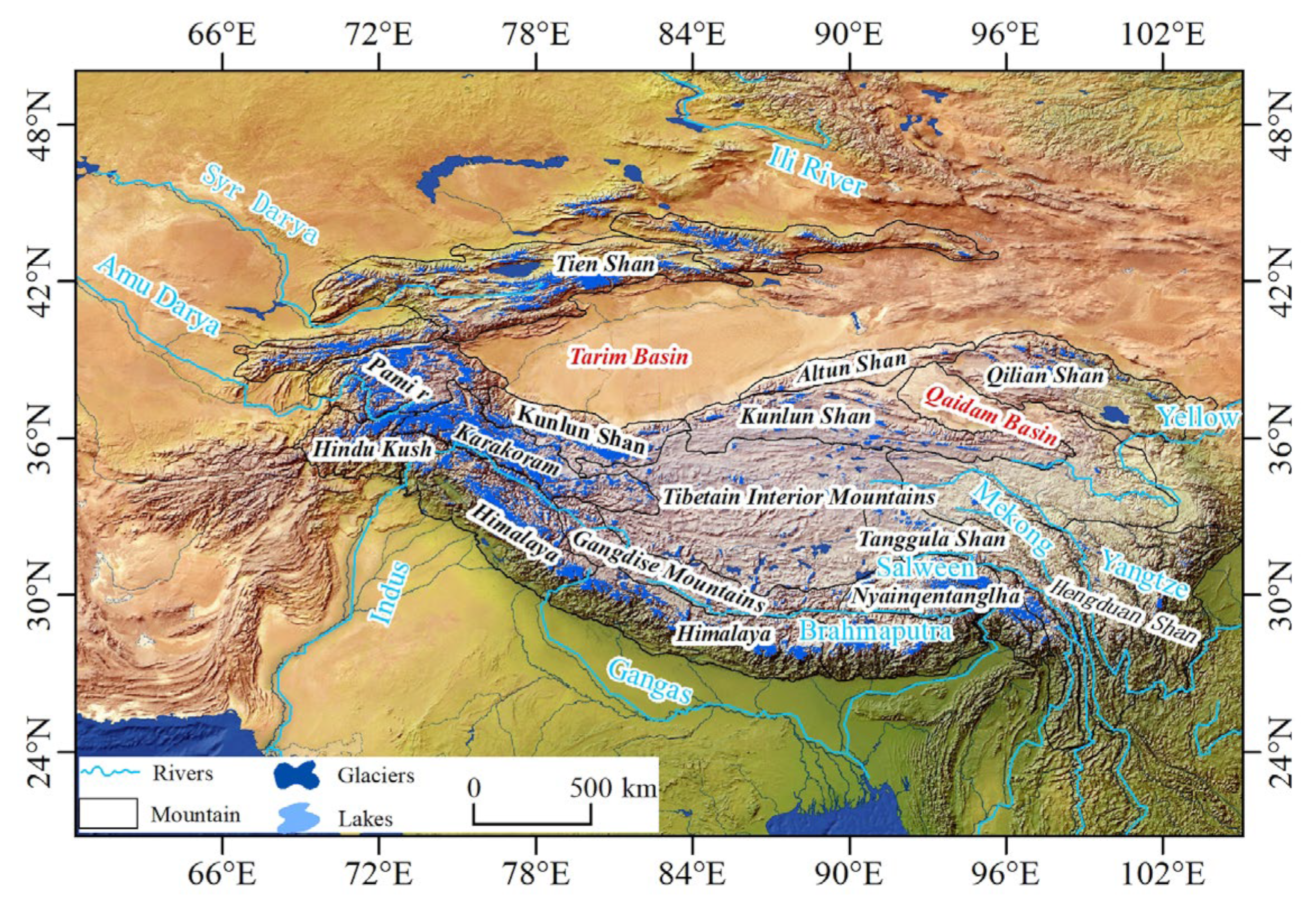
Table 1.
Changes of glacier area in different basins in the Karakoram region.
| Research Area | Area Change (km2) | Time Range (a) | Average Annual Area Change Rate (% a−1) | Data and Methodology | References |
|---|---|---|---|---|---|
| Karakoram | +23.45 ± 28.85 | 1990–2020 | +0.10 ± 0.13 | Landsat TM/ETM+/OLI, Computer-aided classification, and visual interpretation of remote sensing images Classification and Visual Interpretation Methods | [41] |
| Nubra Basin | −103.24 | 1993–2015 | −0.20 | Landsat TM/ETM+/OLI, Ratio Thresholding, and Visual Interpretation Methods | [33] |
| Shyok Basin | −83.53 ± 326.55 | 1993–2016 | −0.05 ± 0.20 | Landsat TM/ETM+/OLI, Visual Interpretation Methods | [35] |
| Gilgit River Basin | −45.82 ± 9.07 | 1993–2016 | −0.18 ± 0.03 | Landsat TM/ETM+/OLI, Visual Interpretation Methods | [36] |
| Shigar Basin | −2.67 ± 14.79 | 1993–2016 | −0.00 ± 0.02 | Landsat TM/ETM+/OLI, Visual Interpretation Methods | [37] |
| Keleqing River Basin | −145.78 | 1978–2015 | −0.22 | Landsat TM/ETM+/OLI, Computer-aided classification and visual interpretation of remote sensing images Classification and Visual Interpretation of Remote Sensing Images | [34] |
Table 2.
Glacier elevation change study methods, data sources, and advantages and disadvantages.
| Research Methods | Data Sources | Advantages | Disadvantages |
|---|---|---|---|
| Field survey method | Flower Rod Measurement, DGPS | High accuracy | High cost and highly influenced by terrain |
| Satellite-carried LiDAR measurements | ICESat-1&2,GLAS | High data accuracy | Data sparsity |
| Synthetic aperture radar measurements | SRTM DEM, ASTER GDEM, TerraSAR-X, TanDEM-X | Not affected by weather | Penetrating to snow and ice |
| Optical stereo image pair measurements | SPOT, ZY-3,Hexagon KH-9 | Low cost, continuous observation, wide range | Highly cloud influenced and limited availability |
Table 3.
Changes in mass balance in the Karakoram Mountains.
| Research Area | Data Sources | Changes in Mass Balance (m w.e.a−1) | Time Range (a) | Glacier Area (km2) | References |
|---|---|---|---|---|---|
| Shigar Basin, Central Karakoram | SRTM DEM, Tan DEM-X DEM | −0.00 ± 0.03 | 2000–2013 | 2895.30 ± 80.69 | [37] |
| Karakoram Mountains | SRTM DEM, SPOT5 DEM | +0.11 ± 0.22 | 1999–2008 | 19,950 | [24] |
| Karakoram Mountains | SRTM DEM, ICESat | −0.03 ± 0.04 | 2003–2008 | 21,750 | [26] |
| Karakoram Mountains | SRTM DEM, Tan DEM-X DEM | −0.020 ± 0.064 (West) −0.101 ± 0.058 (East) | 2000–2014 | [48] | |
| Karakoram Mountains | KH-9, SRTM DEM | −0.09 ± 0.03 | 1973–2000 | 12,365 | [47] |
| Karakoram Mountains | SRTM DEM, ICESat | −0.10 ± 0.06 | 2003–2008 | 21,000 | [7] |
| Central Karakoram Glacier | TanDEM-X DEM, SRTM/X-SAR DEM | −0.08 ± 0.10 | 2000–2012 | 1107.23 | [43] |
| Siachin Glacier East Karakoram | Cartosat-I, KH-9, SRTM DEM | –0.03 ± 0.21 | 1999–2007 | 937.7 ± 16.9 | [46] |
| Karakoram Mountains | SRTM DEM, ICESat, SPOT, TerraSAR-X, TanDEM-X | −0.11 ± 0.18 | 2003–2019 | 24,700 | [45] |
| Karakoram Mountains | SRTM DEM, ICESat-2 | +0.02 ± 0.09 | 2000–2021 | 16,800 | [49] |
Table 4.
Glacial surges in different mountain systems in HMA.
| Research Area | Number of Surging Glaciers | Data Sources | Surging Glacier Identification Method | Time Range (a) | References |
|---|---|---|---|---|---|
| HMA | 244 | Landsat TM/OLI, DEM, ITS_LIVE | Glacier surface (elevation, flow velocity, features) | 1986–2021 | [58] |
| 362 | Landsat TM/OLI/ETM+/MSS/TIRS, DEM, RGI V6.0 | Glacier surface (elevation, flow velocity, features), glacier-terminal changes | 1972–2019 | [32] | |
| 137 | Landsat TM/OLI | Glacier-terminal changes | 1989–2019 | [62] | |
| 666 | DEM, ITS_LIVE, Google Earth, Bing Maps | Glacier surface (elevation, flow velocity, features) | 2000–2018 | [78] | |
| Karakoram | 94 | Landsat TM/OLI, DEM, ITS_LIVE | Glacier surface (elevation, flow velocity, features) | 1989–2021 | [58] |
| 127 | Landsat TM/OLI/ETM+/MSS/TIRS, DEM, RGI V6.0 | Glacier surface (elevation, flow velocity, features), glacier-terminal changes | 1972–2019 | [32] | |
| 172 | Landsat, ASTER | Glacier-terminal changes | 1840–2017 | [59] | |
| 137 | Landsat TM/OLI, DEM, RGI V6.0 | Glacier surface (elevation, flow velocity, features), glacier-terminal changes | 1975–2019 | [61] | |
| 90 | Landsat TM/ETM+/MSS, ASTER, JERS-1, DISP | Glacier surface (elevation, flow velocity, features), glacier-terminal changes | 1960–2011 | [60] | |
| 106 | ASTER, RGI V6.0 | Glacier-terminal changes | 1961–2013 | [64] | |
| 101 | Landsat, DEM, ASAR, TerraSAR-X, TanDEM-X, ERS-1/2 SAR | Glacier surface (elevation, flow velocity, features), glacier-terminal changes | 1976–2012 | [77] | |
| 221 | Landsat, ASTER | Glacier-terminal changes | 1984–2017 | [59] | |
| Pamir | 91 | Landsat TM/OLI, DEM, ITS_LIVE | Glacier surface (elevation, flow velocity, features) | 1988–2020 | [58] |
| 134 | Landsat TM/OLI/ETM+/MSS/TIRS, DEM, RGI V6.0 | Glacier surface (elevation, flow velocity, features), glacier-terminal changes | 1972–2019 | [32] | |
| 202 | Landsat TM/OLI/ETM+/MSS, SRTN DEM, ASTER, Corona, Hexagon, TanDEM-X, Google Earth, Bing Maps | Glacier surface (elevation, flow velocity, features), glacier-terminal changes | 1960–2018 | [52] | |
| 151 | Landsat TM/OLI, DEM, RGI V6.0 | Glacier surface (elevation, flow velocity, features), glacier-terminal changes | 1977–2019 | [61] | |
| 215 | Landsat, ASTER, TerraSAR-X, | Glacier-terminal changes | 1975–2006 | [74] | |
| 820 | ASTER, RGI V6.0 | Glacier-terminal changes | 1861–2013 | [64] | |
| 186 | Landsat TM/OLI/ETM+/MSS, SRTN DEM, ASTER, Corona, Hexagon, TanDEM-X, Google Earth, Bing Maps | Glacier surface (elevation, flow velocity, features), glacier-terminal changes | 1988–2018 | [52] | |
| Kunlun Shan | 24 | Landsat TM/OLI, DEM, ITS_LIVE | Glacier surface (elevation, flow velocity, features) | 1987–2021 | [58] |
| 20 | Landsat TM/OLI/ETM+/MSS/TIRS, DEM, RGI V6.0 | Glacier surface (elevation, flow velocity, features), glacier-terminal changes | 1972–2019 | [32,61] | |
| 10 | Landsat, TerraSAR-X, TanDEM-X, DEM | Glacier surface (elevation, flow velocity, features), glacier-terminal changes | 1970–2020 | [63] | |
| 9 | Landsat, ASAR, ERS-1/2 SAR, ALOS, TerraSAR-X | Glacier surface (elevation, flow velocity, features), glacier-terminal changes | 1972–1992 | [72] | |
| Tien Shan | 10 | Landsat TM/OLI, DEM, ITS_LIVE | Glacier surface (elevation, flow velocity, features) | 1990–2010 | [58] |
| 32 | Landsat TM/OLI/ETM+/MSS/TIRS, DEM, RGI V6.0 | Glacier surface (elevation, flow velocity, features), glacier-terminal changes | 1972–2019 | [32,61] | |
| 39 | Landsat TM/OLI/ETM+/MSS, SPOT, Hexagon, Cartosat-1, SRTM DEM | Glacier surface (elevation, flow velocity, features) | 1964–2014 | [55] | |
| 48 | Landsat TM/OLI, DEM, ITS_LIVE | Glacier surface (elevation, flow velocity, features), glacier-terminal changes | 1990–2019 | [54] | |
| Tibetain interior mountains | 4 | Landsat TM/OLI, DEM, ITS_LIVE | Glacier surface (elevation, flow velocity, features) | 1989–2021 | [58] |
| 23 | Landsat TM/OLI/ETM+/MSS/TIRS, DEM, RGI V6.0 | Glacier surface (elevation, flow velocity, features), glacier-terminal changes | 1972–2019 | [32] | |
| 11 | ASTER, Landsat, TerraSAR-X, TanDEM-X, NASA DEM | Glacier surface (elevation, flow velocity, features), glacier-terminal changes | 1986–2020 | [56] | |
| 11 | Landsat TM/OLI/MSS, SRTM DEM, SPOT, ASTER | Glacier surface (elevation, flow velocity, features), glacier-terminal changes | 1973–2013 | [57] | |
| 39 | Landsat TM/OLI, DEM, RGI V6.0 | Glacier surface (elevation, flow velocity, features), glacier-terminal changes | 1973–2018 | [61] | |
| Himalaya | 3 | Landsat TM/OLI, DEM, ITS_LIVE | Glacier surface (elevation, flow velocity, features) | 1990–2020 | [58] |
| 7 | Landsat TM/OLI/ETM+/MSS/TIRS, DEM, RGI V6.0 | Glacier surface (elevation, flow velocity, features), glacier-terminal changes | 1972–2019 | [32] | |
| 9 | Landsat TM/OLI, DEM, RGI V6.0 | Glacier surface (elevation, flow velocity, features), glacier-terminal changes | 1977–2018 | [61] | |
| Nyainqentanglha | 2 | Landsat TM/OLI, DEM, ITS_LIVE | Glacier surface (elevation, flow velocity, features) | 2015–2018 | [58] |
| 1 | Landsat TM/OLI/ETM+/MSS/TIRS, DEM, RGI V6.0 | Glacier surface (elevation, flow velocity, features), glacier-terminal changes | 1972–2019 | [32] | |
| 1 | Landsat TM/OLI, DEM, RGI V6.0 | Glacier surface (elevation, flow velocity, features), glacier-terminal changes | 2014–2018 | [61] | |
| Hindu Kush | 2 | Landsat TM/OLI, DEM, ITS_LIVE | Glacier surface (elevation, flow velocity, features) | 1989–2020 | [58] |
| 6 | Landsat TM/OLI/ETM+/MSS/TIRS, DEM, RGI V6.0 | Glacier surface (elevation, flow velocity, features), glacier-terminal changes | 1972–2019 | [32] | |
| 6 | Landsat TM/OLI, DEM, RGI V6.0 | Glacier surface (elevation, flow velocity, features), glacier-terminal changes | 1989–2019 | [61] | |
| Tanggula Shan | 10 | Landsat TM/OLI, DEM, ITS_LIVE | Glacier surface (elevation, flow velocity, features) | 1986–2015 | [58] |
| Qilian Shan | 1 | Landsat TM/OLI, DEM, ITS_LIVE | Glacier surface (elevation, flow velocity, features) | 2002–2005 | [58] |
Disclaimer/Publisher’s Note: The statements, opinions and data contained in all publications are solely those of the individual author(s) and contributor(s) and not of MDPI and/or the editor(s). MDPI and/or the editor(s) disclaim responsibility for any injury to people or property resulting from any ideas, methods, instructions or products referred to in the content. |
© 2023 by the authors. Licensee MDPI, Basel, Switzerland. This article is an open access article distributed under the terms and conditions of the Creative Commons Attribution (CC BY) license (https://creativecommons.org/licenses/by/4.0/).
Share and Cite
MDPI and ACS Style
Li, J.; Sun, M.; Yao, X.; Duan, H.; Zhang, C.; Wang, S.; Niu, S.; Yan, X. A Review of Karakoram Glacier Anomalies in High Mountains Asia. Water 2023, 15, 3215. https://doi.org/10.3390/w15183215
AMA Style
Li J, Sun M, Yao X, Duan H, Zhang C, Wang S, Niu S, Yan X. A Review of Karakoram Glacier Anomalies in High Mountains Asia. Water. 2023; 15(18):3215. https://doi.org/10.3390/w15183215
Chicago/Turabian StyleLi, Jiawei, Meiping Sun, Xiaojun Yao, Hongyu Duan, Cong Zhang, Shuyang Wang, Shuting Niu, and Xin Yan. 2023. "A Review of Karakoram Glacier Anomalies in High Mountains Asia" Water 15, no. 18: 3215. https://doi.org/10.3390/w15183215
Note that from the first issue of 2016, this journal uses article numbers instead of page numbers. See further details here.